Showing posts with label google. Show all posts

Monday, November 17, 2008

The Next, Next Street Art

Street With A View is a performance/digital art hybrid (I know! So rad!) coordinated by a small team of artists, residents of Pittsburgh's North Side, and Google. The artists thought up the idea to create vignettes in the city's streets that would be coordinated with when Google's Street View camera car would drive down those same streets. They tapped local residents to act out a series of scenes, coordinated with the Googleheads, and the rest is history.

SWAV's staged "interventions," as the team refers to them, point out an interesting possibility for street art. Referring to an earlier post on the subject, tech like RFID chips and barcodes will make digital graffiti a more ready possibility in the future. SWAV highlights one of the many ways that this type of art could be achieved: take a 360˚ photo (of which there are plenty freely available through Street View for an enterprising hacker), doctor it, and attach it to an RFID chip installed inconspicuously nearby. Set it up with an automatic trigger, and any passersby with an iPhone or a Blackberry will be treated to an alternate reality version of the place that they're walking through.

Aside from the potential for humor, there is political potential here as well. Think of preservationists looking to impress upon people the importance of preventing the destruction of historic structures; take the current, well-publicized battle over St. Vincent's in Manhattan, for example. A skilled digital artist with a penchant for quirky 1960s-vintage low-rises could create a digital, 360˚ recreation of the intersection of 7th Ave and 12th Street in which to-scale renderings of the 300 and 233 foot towers planned by the adjacent hospital replaced the distinctive O’Toole Medical Services Building. Passersby could get a better sense of the scale and blandness of the new development than they ever could from a wallet-sized picture in the Times.

Inverting the perspective, SWAV says some interesting things about Google's Street View feature as well. When examining the interventions on the Google Maps website, try to imagine what a normal user, unaware of the SWAV project, might think when encountering the digital parade. At the same time that it makes Google Street View more fantastical, SWAV also makes it, in a way, seem a bit more real. Certainly moreso in examples like the moving truck or the garage band practice. Add to that the impromptu "meta-interventions" staged by locals unaware of the project until it was happening, and the lines between reality and digital representation get delightfully blurry.

To ponder: If people become more aware of the Google Street View camera car and scenes like those staged by SWAV become more common (which seems very plausible, I think), what role does the Street View feature take on? Its parallel reality becomes heightened; humor and politics are woven into the scenery, and become as valid as the built environment that the feature was intended to represent. In addition, what does a more theatrical representation on the web mean for the real place being represented? If one were to walk down Sampsonia Way in Pittsburgh -- a charmingly "Pittsburgh" kind of street -- would it seem boring? Less authentic or interesting than its Street Views counterpart? Does the digital city draw from the real city, or add to it?


(Photo from Street With a View. The original full-sized color version can be viewed by clicking the photo.)

Thursday, September 18, 2008

The Bean


New updates to Chicago on Google Maps' satellite coverage finally show The Bean and a completed Millennium Park. In case you were wondering if every last square inch, including the very tip-top, is polished, here's your proof.

Monday, August 4, 2008

A bit of color...

Tonight's storm in Chicago:


And, oh god...Tokyo is on Google Street Views...


Thursday, November 8, 2007

World Urbanism Day

In honor of World Urbanism Day (aka Town Planning Day), I thought it would be interesting to take a look at what might become of some of the world's great cities if global warming's worst case scenario came to pass. Scientists estimate that, were all of the ice caps and snow pack on earth to melt, the sea level would be somewhere between 230-260 feet (70-80 m) higher than it is today.

While no one reading this post is likely to see this kind of damage, it's interesting to imagine what today's cities would look like in such a radically different world -- but the scale is so vast that it's hard to fathom. The following is a simple visualization of the landscapes of twelve major coastal cities around the world in three imagined futures: red overlays represent areas that will be submerged after a 50 foot (15.2 m) sea level rise; orange overlays represent areas submerged after a 150 foot (45.7 m) rise; and yellow overlays represent areas submerged after a full 250 foot (76.2 m) rise. The colors represent the fire-like spread of the ocean inland. Take these pictures for what you will; they are what they are.

While many of the cities represented were included for their global importance today, the visual impact of the colored overlays played a big part in determining what cities made the list. The numbers below each square image describe the approximate length of one side in miles/kilometers.


New York City, United States
(74.5/120)


Montreal, Canada
(54.7/88)


Rio De Janeiro, Brazil
(26/42)


Abidjan, Côte d'Ivoire
(28.6/46)


London, Great Britain
(16.8/27)


Stockholm, Sweden
(22.4/36)


Istanbul, Turkey
(22.4/36)


Mumbai, India
(53.4/86)


Sydney, Australia
(22.4/36)


Hong Kong, China
(18.6/30)


Pyongyang, North Korea
(20.5/33)


Tokyo, Japan
(83.9/135)


------------------------


The images above were created using Google Maps and a filter from Hey What's That dot com.


Links:
World Urbanism Day (Wikipedia)

Google Maps

HeyWhatsThat.com (EDIT: I found a direct link to the tool that I used.)

Monday, September 3, 2007

Alaska From Above

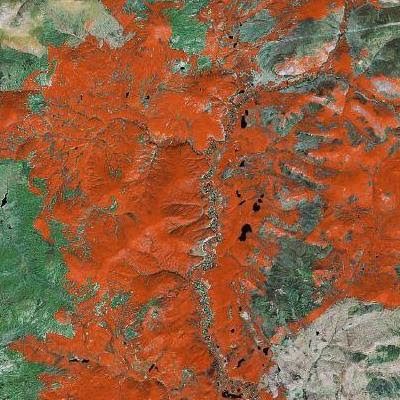
While the hi-res satellite imagery on Google Earth is pretty fascinating, there is something to be said for the saturated, gauzy low-res views still aviailable when zoomed far enough out (or when hi-res is not available for a certain area) on good old-fashioned Google Maps. Especially over uninhabited areas, these bright, sometimes abstract images can have a sort of "lost world" mysterioso-vibe to them that I find particularly intriguing. But then, I still have an affinity for MS Paint, so I might just be an advanced Luddite, after all.

Still, for those who would disagree about the artistic power of crappy Crayola-toned satellite photos, I will make my argument with some rare (for this blog) color photos. These are taken directly from Google Maps, though I was not smart enough when snapping the shots with PrintScreen to save the url for each location. If you enjoy these, go do some Googlexploring of your own. Being that most of Alaska is untamed wilderness, it's a great place to start...


If you find any good stuff on your own (in Alaska or elsewhere) be smarter than I was -- post the url as a comment. Happy 'sploring.

Thursday, June 28, 2007

The Dawn of Digital Urbanism


Blog Like You Give a Damn put up a great post last month on recent advances in online urban cartography (like Google's über-controvertial Street Views) and how these new digital reinterpretations of the world are moving us toward William Gibson's vision of cyberspace as a physically inhabitable place. From BLYGAD:

"Unlike the cyberspace that Gibson describes in [his book] Neuromancer:

'...a graphic representation of data abstracted from banks of every computer in the human system. Unthinkable complexity. Lines of light ranged in the nonspace of the mind, clusters and constellations of data. Like city lights, receding...' (69)

this new cyberspace will be much more familiar to us. It will look and behave in ways we understand - dangerous because the line between real and virtual will be that much more hazed. As the possibilities for exploration, learning, and knowledge building expand - so too will the potential for surveillance, misuse, and abuse."


Cyberspace is Shangri-la for the internet generation: a mythic miracle of a place that we are sure exists just over the horizon, within a whisper's length of our grasp. Each person has their own idea of this place painted in their mind, but I think the truth about an inhabitable Cyberspace is that it will be very much like Gibson's fantastical vision. It will also be very familiar to us, as BLYGAD predicts. In fact, our physical reality is already merging with its virtual counterpart. For, as the hyperconnectivity brought on by the rise of the internet becomes integrated into the urban fabric, understanding of one's physical environment is becoming more inextricably tied to one's understanding of the web itself. The melding of the physical and virtual (cyber) worlds is already taking place on both ends, with each side moving quickly toward the other. Eventually, of course, they'll meet somewhere in the middle.

We can see this trend online as the "clusters and constellations of data" described by Gibson are being harnessed to create a sort of digital urbanism, recreating various aspects of the physical world for Cyberspace. Akamai recently launched a tool -- Visualizing the Internet -- that has been described as a weather report for the web. Meanwhile, an online art project called We Feel Fine (profiled in the June issue of Metropolis) mimics the richly frenetic atmosphere of a busy public space without actually replicating any of the recognizable features of physical places. If the aforementioned Google Street Views is representational digital urbanism, We Feel Fine is the presentational version, capturing the essence of public space in a wholly new way, reorganizing the traditional tokens of public spaces (trading visual diversity for emotional diversity) into a "place" that could only exist online.

Good old-fashioned bricks and mortar urbanism, meanwhile, is getting a digital overhaul as handheld, web-enabled devices and wireless internet for laptop users takes the edge off of some this system's perennial problems. I'll take any chance I can get to highlight Urbanspoon, a site that catalogs every restaurant in several major US cities (DC was recently added), aggregates reviews from major websites, allows for user ratings and reviews, and provides neighborhood breakdowns via kickass "nighttime" maps that show the locations of all of the cities' eateries. Finding a great restaurant has never been so easy. Another genius web service, recently covered on Springwise, is MizPee, a San Francisco-based service that allows users to access a list of nearby public restrooms, eliminating one of the chief drawbacks of pedestrianism.

As cities become more digitally enabled, they are also starting to bleed together. Geographic constraints have been removed from art and culture in the same way that they were from commerce. Even street fashion has crossed over into the digital realm. As the David Report...well...reports, cities across the globe will be represented in "Street Clash," a blog where the tragically hip artkids from dozens of cities will go head-to-head in an effort to determine which city has the ultimate street style. The irony of this is that, while individuals can rep their hometowns in a token sense, they are still independent human beings free to change their geography at any time. That is to say that what is happening here is the formation of an international street style, as a handful of people cannot be representative of an entire urban population. Hipster fashion has been globalized. Whether this is good, bad, or just hilarious is still a question mark.

As BLYGAD's post points out, the transition of the physical world into the Cyberspace of the future could open a Pandora's Box of new social, ethical, and safety concerns. Pittsblog reported yesterday on a proposal from the city of Pittsburgh for a massive urban surveillance system. Mike Madison, who writes the blog, had this to say: "Hopefully the public will respond...to the proposal's Benthamite implications...It's one thing (though it's not necessarily a good thing) to be watched when you know that you're being watched. It's something else entirely -- and rarely a good thing -- to be watched all the time, when you don't necessarily know it" (emphasis his). Madison then asks the age-old question, "who will watch the watchers?" This, I think, will be the most fundamental challenge of Cyberspace: in a universally connected world, the unwatched watcher has more power than ever, as they will have unprecedented access to the masses.

As the internet becomes increasingly ubiquitous and reality moves toward the virtual, the emergent Cyberspace will almost certainly take on an urban form -- though it remains to be seen whether it will lean more heavily on the physical or virtual world. Either way, geography will become less and less binding as cities learn to connect in ever more complex ways, and we will likely come to understand urbanism as something very different from what it is now. Shangri-la is upon us.

(Photo from Flickr user 3views.)


Links:
New Urban Cartography (Blog Like You Give a Damn)

Visualizing the Internet (Akamai)

We Feel Fine

Urbanspoon

Mobile Loo Locator (Springwise)

Street Clash (David Report)

The Pittsburgh Panopticon (Pittsblog)