Showing posts with label new york. Show all posts

Friday, July 17, 2009

The New High Line

Photo of the High Line pathway

The High Line is an elevated park that runs along a portion of Manhattan's west side. It was once a railway, in use from 1934 until 1980. As vegetation took over, it became an informal and (not completely) inaccessible greenway above the streets. Neighborhood residents Joshua David and Robert Hammond started Friends of the High Line in 1999, hoping to save the structure from demolition and build support for the park idea. The city approved funding in 2004, and the lower section (from Gansevoort to 20th Street) opened in June.

Photo of trees and benches along the High Line

The park was designed by James Corner Field Operations, Piet Oudolf, and Diller Scofidio + Renfro. It is made up of pathways that weave through the original train tracks, as well as diverse plants inspired by those that grew in the absence of maintenance. The city plans to continue the park along the Hudson Yards to the Javits Convention Center. According to Mayor Bloomberg, the first section has sparked considerable neighborhood development, with more than 30 new plans now in the works. The Whitney Museum is building an extension by Renzo Piano at the Gansevoort entrance.

Photo of plantings along the High Line

On a recent visit, I was impressed by the High Line's varied landscape and playful atmosphere. It offers a different perspective on the city, where things come into view that are usually hidden from street level. The path moves along and through buildings, creating excitement in the discovery of new environments.

Photo of the theater onto the street at the High Line

The architecture is kind of slick, but it also has a relaxed, inventive feel that plays well against the seasoned ruggedness of its surroundings. I really like the idea of including the original train tracks. This might be even better if their continuity could somehow be maintained. They currently seem like set pieces rather than historically integrated parts of the neighborhood. I loved the rolling chairs on tracks, and the vegetation is tough and beautiful. The spectator windows onto the street (or into the park) are an interesting concept, framing everyday life as entertainment. However, I'm not sure the frames and stepped seating add much to the view, and they seem to draw energy away from the path. These opinions, however, are especially inconsequential in light of the overall greatness of the park.

Photo of rolling chairs on tracks at the High Line

The High Line is a wonderful part of the city's changing ecology, one that builds upon the old in shaping the new. I recommend starting with the exhibition Mannahatta/Manhattan: A Natural History of New York City at the Museum of the City of New York. It includes detailed reconstructions of the island before modern development, giving a sense of how our current moment fits within the area's unfolding story.

(Photos by Peter Sigrist)

Monday, May 4, 2009

Urban Afflictions. Global Health Crises in Metropolitan Contexts. An interview with Hilary Sample

Ice cream and influenza. Mexico City

The global crisis unleashed by the 2003 SARS outbreaks seemed all but forgotten in most parts of the world, until the threat of a global pandemic resurfaced in the media (old and new) only a few days after the appearance of a mysterious, unknown and presumably deadly virus in Mexico City. In a crazy turn of events, the megacity was practically shut down and brought to a standstill for days, with consequences that we are only beginning to come to terms with.

What have we learned from these massive public heath crises that are a product of our interconnected, now predominantly urban world? How are governments, institutions and organizations (at the local, national and global scales) reacting to these crises in terms of urban policies and design? We’ve asked Hilary Sample, Assistant Professor at the Yale University School of Architecture and partner of mos, to comment on these issues, taking her upcoming book, Sick City, as a point of departure.


Where: First of all, can you give us some insight on the subject of your book, Sick City? What exactly would you say is a "sick city", or a "healthy city" for that matter?

Hilary Sample: Sick City is a book project that began during the SARS outbreaks in 2003. I became interested in the sudden, urban shifts that took place as a result of the outbreaks while I was living and teaching in Toronto, and examining the post-event effects. The book is not only about SARS, it starts with SARS as the first major global health crisis event in the 21st century, but also focuses on other urban crises; looking at the problems and solutions that result from contagious disease situations or threats, from hurricane Katrina to AIDS. Essentially, I was interested in the unpredictable events that were not malevolent causes, and the urban remedies.

The SARS outbreaks became true public crises in March 2003, within weeks, if not days, of the start of the Iraq War. The media focus in North America was practically concentrated on the war up until the SARS outbreaks, which became a focal point of news coverage in Canada, and it seemed to me that this divide between terror and disease was significant in its own right. Each would have (and has had) a great effect in terms of socioeconomics, health and urbanism. It was interesting to see the difference between the U.S.’s concern regarding terrorism and Canada’s concerns about the spread of SARS. There is no question that war is so devastating because of its physical consequences, I think, but in the moment, disease outbreaks are no less significant, though the aftermath is usually subtler and as a result seems less significant. Still, the consequences of a disease like SARS have had major urban effects, such as the development of the Biomed City (we get into this further on in the interview).

In the terms of the book, a sick city is one that has undergone an unexpected change as a result of disease; a city whose life-sustaining infrastructures have been affected beyond their intended performance. The book also looks at the governance of world health, the agencies and foundations doing this work and the development of the health headquarter building, a new typology that emerged in the twentieth century, which defines the way worldwide health is organized. (An early paradigm is Le Corbusier’s Ministry of Health and Education building, in Rio de Janeiro.) Sick City looks at building types associated with health and examines their performance. It’s a kind of loop, looking at the sick city, its sick buildings and the organizations that renew and restore the city, and then looking at buildings that are meant to facilitate urban health.

Reforma Avenue. One of the main (usually crowded) throughfares in Mexico City.

W: What is your reaction to the current 2009 A/H1N1 flu affair? Where do you see our cities standing compared to the first SARS outbreak in terms of being prepared (or not) for this kind of public health crises?

HS: Disease is unpredictable, but there are social and spatial patterns that emerged with SARS and are emerging again now: school closings, hospitals restricting access to only the sick or even designating parts or entire hospitals for the infected, scanning at the airport. The big question will be how these events are handled and what they look like.

With SARS, everything happened so fast that hospitals, for example, were closed or cordoned-off, wrapped in yellow tape, limiting entrances, looking more like a crime scene than a hospital. These instances caused more fear and panic than were probably necessary; keeping individuals from going out in public, from doing normal activities like eating out or taking public transportation. This fear and resistance to going out in public has significant economic impacts on a city. Compounded with a weak global economy, this will raise new challenges to the operation of public health facilities. In the U.S. and Canada, there has been a great push to build new research space in cities for the purpose of identifying contagious diseases to pollutants.

Super Hospital. Birmingham, U.K.

W: Can you give us some examples of how these global health crises are changing our cities in terms of urban design and infrastructures? I imagine that certain building types (hospitals, quite obviously) would be almost immediately affected.

HS: The hospital is our most contested urban building type today. Unlike any other building type within the last fifteen years, hospitals have been the site of significant urban trauma, form war or terrorist targeting, to takeovers and quarantines. At the time of the SARS epidemic, the hospital was the place where most of transmissions of the disease occurred, as the virus often spread to health care workers, other patients and visitors. In the aftermath of Katrina, in New Orleans or Galveston, many hospitals closed and remain closed.

At the same time, we see different types of hospitals on the horizon, a new breed of “super hospitals”.

We see this idea of the super hospital establishing itself in the U.K., and plans are under way for this type of development in Montreal. There is a project under construction in New York City, the East River Science Park (ERSP), which is really anything but a park. It is a research institution that is being built adjacent to one of New York City’s most celebrated hospitals, Bellevue Hospital. Unlike its counterpart in Toronto, the ERSP has little space dedicated to the public. Toronto’s MaRS project, an addition to the original 1913 Toronto General Hospital building, includes a public atrium which links into the rest of Toronto underground system, a public auditorium, and even a food court. The hospital became too costly to repair for use as a hospital, and now has been renovated and added to for office and lab space. It really acts as a place for meeting in the city.

Even though both projects are being built by the same developer (not coincidentally) they are fundamentally different: MaRS promotes an exchange between the public and the user, where ERSP has strict entry controls and checks. Here we see the difference in mindset between the US and Canada, one city affected by 9/11 and the other by SARS. One would expect the opposite kind of spatial response — a prophylactic situation emerging where germs had been spread — but in fact Toronto’s MaRs development has public spaces and links to both the Toronto General Hospital and the Toronto underground system and subway.

SARS: Yesterday's news?

W: At an even larger scale, another extremely interesting concept in Sick City is the idea of the “Biomed City” you mentioned earlier. What exactly is a BMC? Does it actually exist somewhere, or is it only hypothetical?

HS: In the book, we see the BMC as a 21st-century urban paradigm emerging from New York, to Toronto, to Singapore. The term has been adopted by various cities, where certain areas — and in some cases entire cities — are adopting this “brand”, placing an emphasis on health and its industries as the new economic driver of the city. One interesting thing to note is that in cities less prosperous, such as Buffalo, New York, the health-care industry is now the largest employer in the city.

In response to the SARS epidemic, Toronto reworked its most visible hospital and introduced the program of rentable office and laboratory spaces dedicated to health research in the downtown urban core. Typically, this kind of work space was only seen in suburban corporate parks. With BMC strategies, we see unlimited configurations of health and work spaces converging.

In Toronto, there has been an all-out effort to build civic buildings at that heart of the city and the U of T, both of which converge at one corner of the city, with new buildings largely built of glass, emphasizing a literal transparency, housing new spaces for health research. There were three reports written after SARS in Toronto, all of which cite a lack of transparency in the health system. Certainly building transparent buildings doesn’t indicate that a city will be better prepared, but it does demonstrate that research related to health is no longer being done in opaque and distant locations.

The sites of these outbreaks are typically the city centers: this is where the capacity for care, research and a quick response is needed. New York, Toronto, Rotterdam, Beijing and Boston, among others, have all built their own biosafety laboratories, which means they don’t need to rely on sending disease samples to national labs and wait for a response. These tests can be performed in the heart of the city. The development of these labs — some of which house lethal viruses — has been strongly contested, particularly in Boston.

W: It’s really interesting to see how all of these factors you mention have resurged in the Mexico City outbreak: problems with lack of transparency and coordination, as well as the issue of immediacy and speed (since Mexico did not have the capacity to identify the new strain, it had to send samples of the virus to Canada and the U.S. before it could be properly detected, delaying the response for days).

HS: This reflects the importance of establishing critical life-sustaining infrastructures (hospitals, research laboratories and mobile care) that should all be available in any urban environment. After the SARS outbreaks, the cities that thought they were the most “prepared” in almost every case found short comings. Many of these cities had major plans on the drawing board, but I have no doubt that in the aftermath of SARS gave them an even stronger and urgent reason to update the city. I don’t think this suggests that we should adopt an emergency urbanism attitude towards designing in the city, it would not be practical to design for full-blown pandemics, but as we’ve seen in the trend of medicine to look to prevention, design can facilitate new methods of spatial organization. I think this is particularly true at the site of the hospital, and the way the general hospital and specialized hospitals are organized in the city today.

Riding the subway in Mexico City

W: We’ll keep discussing these and other issues (including government involvement, networked responses, flexible infrastructures, and the gap between prepared and unprepared cities) in the second part of this interview. Stay tuned. In the meantime, you can download a PDF version of "The Biomed City" from the Actar blog.


(Photos from Flickr users amegally, pvcg, seth trotman, zverina.com and eneas. The original full-sized color version can be viewed by clicking the photo.)

Tuesday, April 28, 2009

In Jane's Footsteps


Get your walking shoes out. This weekend (May 2 and 3) is the annual Jane's Walk, dedicated to everyone's favorite grassroots urbanist. Inspired by Jane Jacobs' close attention to the everyday experience of urban life as it unfolds on the ground as a basis for understanding and acting upon the city, volunteers will lead free walking tours in over 200 neighborhoods in North America, and for the first time, in India (where PUKAR will lead the way). Organized by the Centre for City Ecology in Canada and by the Center for the Living City in the US, Jane's Walk included over 6000 participants last year, its second in existence. Many tours focus on the built environment, but others touch on local culture, history or crucial planning issues. It's not too late to lead your own...

The walks celebrate Jacobs' simple and groundbreaking idea that in order to figure out what will work for cities, one has to look at how people actually experience the city at ground level and plan with people at the center, rather than on the basis of car traffic, utopian models or scientific formulas. Not a formally trained planner herself, Jacobs' principles (higher densities, mixed uses, short blocks) are now the ABC's of the field. More importantly, her promotion of community-based planning as a counterpoint to top-down master-planning was responsible for a vast paradigm shift. It's no accident that Where readers voted her seminal treatise, The Death and Life of Great American Cities, into the top position of our list of best books for the novice urbanist.

To what extent have Jane's footsteps left a lasting imprint? According to Hilary Ballon, an architectural historian at NYU quoted in the NY Times' City Room blog, this is a "'golden moment for the rebirth of city planning... after a long period of tremendous suspicion about the viability and value of a master plan' — suspicions fueled by a perception of 'evil top-down planners who didn't understand what neighborhoods needed.'" She was introducing a talk on April 15 by Daniel L. Doctoroff, deputy mayor until early 2008, on PlaNYC, what he called '"one of the most sweeping, most comprehensive blueprints for New York ever undertaken."

Based on the premise that New York's population is expanding rapidly, its infrastructure is aging, and its environment is at increasing risk from climate change, PlaNYC lays out a detailed framework for meeting goals in the arenas of land, water, transportation, energy, air and climate change. The plan was created after a four-month public outreach process, including consultation with advocacy groups and town hall meetings in all five boroughs. With characteristic NYC bravado, the plan claims to be a model for city planning in the 21st century.

Are we indeed witnessing the rebirth of far-reaching master-planning, but with new features? Is this a happy medium: planning for tomorrow while making residents' needs and voices central? Or are Jane Jacobs' views on the importance of keeping our feet on the ground and involving communities being diluted to token community outreach meetings?

(Flyer from the Center for the Living City. Photo of Jane by Maggie Steber, Planning Magazine, 1986, sampled here.)

Tuesday, February 24, 2009

Economic Stimulus: Not a Spectator Sport

Long before President Obama signed the stimulus bill into law, municipalities across the United States had already begun salivating, and understandably so—the bill promises to spread CRAZY moolah across this economically-troubled country. Unless you’ve been on an extended camping trip, of course, you already know about the stimulus bill.

A variety of websites have emerged lately to solicit stimulus project suggestions and feedback from the masses. Stimuluswatch.org, for example, aggregates specific projects that are candidates for funding via the bill while acting as a forum for discussing their merits and drawbacks. As Catherine Rampell puts it, the stimulus is being crowdsourced. This is a manifestation of civic involvement that no one could have envisioned in the New Deal era. We can only hope some folks in Washington take a look at the message boards.

It may seem silly to nitpick about where the stimulus funds go, as long as they create jobs. Your city wants to secure the biggest chunk of cash it can get, and it wants project proposals that will attract that cash. During another economic upheaval, the Great Depression, Robert Moses demonstrated the pitfalls of that mentality in New York City. Moses noticed that Washington was handing out New Deal money and that few cities had projects on which to spend it. By catching on to this before many others did, Moses managed to almost single-handedly execute public works projects like the Triborough Bridge while elevating himself to an autocratic level of power in New York. Many of the New Deal projects he oversaw helped to choke the five boroughs with automobile traffic, and his influence—good and bad—is still felt in New York City today.

An individual with the power Moses had is unlikely to appear again in a U.S. city, but his legacy reminds us that large-scale federal funding enables the kinds of mega-projects that induce seismic change in cities. Under the guidance of mere mortals, those projects have the potential to harm cities just as easily as they can help them. As your city works to secure its stimulus money in 2009, examine the use of that money with a critical eye.


(Photo from Flickr user Tracy O.)

Tuesday, February 3, 2009

Posh to be Poor? Food

Food is a hot topic these days and will continue to be in the next few decades as Earth's population grows to record numbers...every year. Food has taken the spotlight high atop the green podium due to the massive amounts of chemical pesticides used for agriculture as well as the enormous amount of transportation-elated energy that is required to provide us all with raspberries in January. Terms such as organic, locavore, CSA, and most importantly community gardening have become common language for many progressive westerners. Over the last decade there has been an increasing trend toward growing one's own food. This can be attributed to the rising costs of food as well as to light being shed on CAFOs and the massive amounts of media attention focused on the conditions in which our foods are grown and nurtured.

Overall, food prices are rising, which isn't exactly helpful to the middle class worker. This is leading to a movement toward homesteading: if you can't afford to buy food, grow it yourself. Shrinking cities are filled with abandoned lots waiting to be developed; however, seeing the state of economy, one can figure that won't be happening for a while. In the meantime, residents in these neighborhoods can capitalize on this open space by planting and harvesting a garden, thereby reducing their grocery costs. There is a significant movement to convince the Feds to plant a garden on the White House lawn. This symbolizes the American movement toward urban gardening and sustaining oneself with the land that one maintains. You don't even need a lot of land to hop on the garden train: some folks in New York have started a Chicken Coop Co-op in their tiny backyard. It's apparently become quite the hit as the local breakfast spot offers a specialty dish using only eggs from this co-op. According to UrbanChickens.org founder K.T. LaBadie,

Their [eggs] production cost is cheap: you can buy chickens for as little as a couple of dollars, and three hens will likely average about two eggs a day. You can also use their waste to help revitalize a garden...There've been recalls on everything from beef to spinach, and I think people want to have peace of mind knowing their food is coming from a very trusted source.


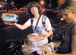
Another trend that has garnished a lot of attention in the last 10 years is the growth of the Freegan Movement. If you aren't familiar, the concept is to eat only what you can find for free. This usually includes scavenging through bakeries' and big box stores' dumpsters for bagged and canned goods. In New York, there was a Freegan group who would throw rooftop parties and everyone was required to bring some found food. I'm not saying it's a great idea, but people are doing it, and loving it. In the western world we tend to undervalue what goes into our bodies. Rarely is a plate scraped clean, and a massive amount of organic waste is created. Likewise, bakeries and grocers overstock, causing outdated items to be pitched. This group capitalizes on the waste of others. For some, dumpster diving has taken on a new image in the 21st century as a rouge sport as opposed to a last resort for the poor. Many of the people taking part in these events have jobs and don't need to dumpster dive. They do it for the experience.

Posh to be Poor? Introduction
Posh to be Poor? Transportation

(Photos from Eat the View, New York Times and Freegan.Info. The original full-sized versions can be viewed by clicking the photos.)

Thursday, January 22, 2009

Wherever you go, there you are.

It struck me the other day, while reading one of Springwise's increasingly frequent posts on the mass customization of travel, that the types of travel apps and sites being developed right now to personalize the urban travel experience could have a profound impact not just on how we visit cities, but on how cities themselves function, as well.

Urban travel has long been a two-sided coin, with time in a new city being divided (in different ratios, depending on the tourist) between the standard landmarks like the Empire State Building, or the Forbidden City, and the day-to-day urban world that exists on the edges of guidebooks; think of Brooklyn back in the 1990s, or Beijing's fast-evaporating hutongs today -- places to which people are drawn to observe the day-to-day lives of other people, to experience the spectacle of the extraordinary-ordinary.

The Postcard City and the Real City are inevitably pitted against each other in a battle for the urban tourist's limited time. But as cities grow bigger and bolder on our increasingly urban planet, it seems fair to assume that greater and greater numbers of tourists will make their way down the streets of cities that they do not call home; as such, the traditional landmarks and attractions become more and more crowded, making the prospect of tooling around a lesser-seen part of the metropolis an increasingly attractive option for visitors.

The aforementioned trendblog has spotted some real doozies lately; a site that allows you to navigate cities by mood (Could Yelp-like testimonials about certain blocks, streets, parks, or even whole neighborhoods define or even change the mood of a given place?); another that uses personal data to create personalized guidebooks (Would the diversity of interests force travel publishers to re-think the meaning of the term "attraction?" I.E. cyclists' internationally competitive quests to speed up the steepest slopes could reboot the way a whole subculture navigates hilly cities like San Francisco, Pittsburgh, Guilin, and Lisbon); and yet another that helps you track down a hot scene at the last minute with crowdsourced GPS data (Anybody up for an impromptu, flashmob-style block party?)

The customization of the urban tourism experience not only makes wandering off the beaten path more common, but more enticing as well, and has the potential to distribute visitors more evenly around the city than old-school printed-paper guides, with their hyper-selective map insets and restaurant listings.

But does this dispersal of small-time explorers legitimize or cheapen the Real City? It seems like an echo of the ongoing argument about gentrification; after all, while tourists themselves are a temporary presence in a given location, their combined influence can be very powerful over time. (You could make a strong case for the influence of tourism in speeding the process of gentrification, itself.) And, while the carving of initials into a famous landmark is a time-honored tradition (as old as the very idea of "landmarks"), the tourists of tomorrow could soon be able to carve their very presence into the city in the unpredictable paths that they cut through it, shifting not only the way that other visitors, but the very citizens of the city in question, navigate and experience a place.

(Photo from Flickr users LondonSLR and neiljs. The original full-sized versions can be viewed by clicking the photos.)

Tuesday, January 20, 2009

Posh to be Poor?


I've been reading a lot of articles lately, and as wrong as it may sound, it seems as though poor is the new black in the Western World. Now I don't mean more people are becoming poor, because that's obviously true, but it seems that lately a lot of professionals have drawn inspiration from the condition. For example, the Times ran an article about architect Teddy Cruz and his social housing experiment in the Hudson River Valley. The development, which features a modern day mesh of architectural elements, draws inspiration and, at times, form, directly from favelas.


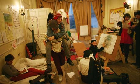
Another prime example is seen in the press that a group of British artists received when they essentially hijacked a vacant multi-million dollar mansion. Late last year, the artist collective Da! moved their group into 18 Upper Grosvenor Street, one of London's more exclusive neighborhoods. They lived and worked here for at least a month with no word from the owners and no word from the cops. I can see this becoming a trend in America, with so many mansions going into foreclosure or sitting on the open market. Perhaps there will be a slight role reversal, where the homeless end up taking over these huge mansions because nobody can afford them or to maintain them. I mean, you can already get 3000 sq ft of 1920's craftsmanship for under 100k in Detroit, why even waste your time with money anymore? Just move in! Some cities are even working on programs to move the homeless into foreclosed homes, according to Fox News. If you want a mansion for nothing, now just may be your chance.

Finally, one of my favorite artists/designers just released a transportable abode for the homeless. I know this has been an ongoing project in every architecture school in the world for the last 50 years, but nobody does it quite like James Westwater. There is something compelling about his project, "homeless chateau," and the idea of living in a rectangular prism in an abandoned warehouse. How different is this from living in a warehouse loft? Having neither heat nor electricity would be rough, but you're not paying $3000 a month. Anyways, I'm not really suggesting these are real lifestyle choices that will become widely popular anytime soon; I'm simply suggesting these ideas are growing in popularity.

In order to dig further into this idea that we are being inspired by the conditions of being poor -- conditions that will increasingly affect the middle class worldwide -- I will investigate 3 divisions of urban planning which directly connect to choices in lifestyle and are dictated by income. Those divisions are Transportation, Food, and Shelter. Over the next 2 weeks I will dive into each category and explore the trends that are leading to a more frugal lifestyle for citizens of big cities.


(Photo from NYT, Gurdian, and James Westwater. The original full-sized color version can be viewed by clicking the photo.)

Friday, November 28, 2008

Dump


The recent New York magazine article on the former Fresh Kills landfill in Staten Island, delineating the plans and hopes for the site’s transformation into an immense park, kicks off with a false ending:

“Let’s start at the end of one story, the story of the dump, with the view from way up on top of it…”

Fresh Kills might not function as or look like a dump anymore, but that doesn’t mean the dump is gone, or that the 53 year-old, 3000 acre-wide “mistake” is finally on its way to being “corrected” (same thing with this month’s Metropolis Mag profile of the alleged future park).

At the risk of this sounding like shameless self-promotion, I want to point to a very different perspective on the whole reclamation affair presented by architect/geographer John May in a book I recently worked on. As others have already highlighted, May’s controversial take on Fresh Kills describes the trash heap as a materialization of a collective morality, a set of basic, unquestioned beliefs that sustain and make operative our everyday reality without us even noticing. May sees in Fresh Kills a frightful memento of an era based on the assumption that “freedom and accumulation are complimentary goals; the recognition that images are commodities; and an unquestioned embrace of a set of hopeful and reactive technological responses, designed to prevent massive accidents that have already happened.” He recognizes that Fresh Kills is tied to a particular development scheme, both in economic and cultural terms.


What counts for the dump, counts for the remediation and redesign of the site. May goes straight to the throat of the Fields Operation proposal for reclamation, despite all its good intentions and wishful 4-step "livingscape" program. All the capping and veiling and the sealing tight are carried out not only to elude dealing with material run-off of the waste, but also to distract from what that waste means and implies and reflects (the architects and the city want to avoid any leaks, physical or moral).

In the urbanism of Fresh Kills, before and after closure, a series of enormous corrective measures and technological “fixes” (along with minor changes in the official rhetoric) are supposed to heal and cleanse and erase the ugly from the site, leaving a landscape that can be consumed without guilt as the “wholly fantastical Photoshop collages of upper-middle clash recreational enjoyment” of the proposal demonstrate. One has a nagging sense of this whole idea of a place set back on the right track, and healing itself back to normal is something of a hoax, “a remarkably compelling lie, beautifully rendered, but a lie nonetheless.” Like people who promise to cure cancer with meditation or massages.

What is to be done then? How can we respond to these overwhelming objects we’ve spun into being and then lost grip on? Do we need to make things better, or do we need to learn from them, even if the learning process is ugly and painful? Is there any way we can do both? The same questions apply to all the vast environmental challenges we’re currently faced with, our cities included.

Tuesday, November 18, 2008

O'Reilly Talks San Francisco Values


I haven't been to San Francisco yet myself, and I have heard tell of their massive homeless population, but this all seems a bit...skewed. Especially considering the source. It's an interesting piece of propaganda, though, and it speaks volumes about the far right's conception of cities. What I find most interesting is the attempt to paint New York as tame and orderly in opposition to San Fran's off-the-wall liberal madness. Seems to say more about New York than it actually does about San Francisco.

Thoughts?

Monday, November 17, 2008

The Next, Next Street Art

Street With A View is a performance/digital art hybrid (I know! So rad!) coordinated by a small team of artists, residents of Pittsburgh's North Side, and Google. The artists thought up the idea to create vignettes in the city's streets that would be coordinated with when Google's Street View camera car would drive down those same streets. They tapped local residents to act out a series of scenes, coordinated with the Googleheads, and the rest is history.

SWAV's staged "interventions," as the team refers to them, point out an interesting possibility for street art. Referring to an earlier post on the subject, tech like RFID chips and barcodes will make digital graffiti a more ready possibility in the future. SWAV highlights one of the many ways that this type of art could be achieved: take a 360˚ photo (of which there are plenty freely available through Street View for an enterprising hacker), doctor it, and attach it to an RFID chip installed inconspicuously nearby. Set it up with an automatic trigger, and any passersby with an iPhone or a Blackberry will be treated to an alternate reality version of the place that they're walking through.

Aside from the potential for humor, there is political potential here as well. Think of preservationists looking to impress upon people the importance of preventing the destruction of historic structures; take the current, well-publicized battle over St. Vincent's in Manhattan, for example. A skilled digital artist with a penchant for quirky 1960s-vintage low-rises could create a digital, 360˚ recreation of the intersection of 7th Ave and 12th Street in which to-scale renderings of the 300 and 233 foot towers planned by the adjacent hospital replaced the distinctive O’Toole Medical Services Building. Passersby could get a better sense of the scale and blandness of the new development than they ever could from a wallet-sized picture in the Times.

Inverting the perspective, SWAV says some interesting things about Google's Street View feature as well. When examining the interventions on the Google Maps website, try to imagine what a normal user, unaware of the SWAV project, might think when encountering the digital parade. At the same time that it makes Google Street View more fantastical, SWAV also makes it, in a way, seem a bit more real. Certainly moreso in examples like the moving truck or the garage band practice. Add to that the impromptu "meta-interventions" staged by locals unaware of the project until it was happening, and the lines between reality and digital representation get delightfully blurry.

To ponder: If people become more aware of the Google Street View camera car and scenes like those staged by SWAV become more common (which seems very plausible, I think), what role does the Street View feature take on? Its parallel reality becomes heightened; humor and politics are woven into the scenery, and become as valid as the built environment that the feature was intended to represent. In addition, what does a more theatrical representation on the web mean for the real place being represented? If one were to walk down Sampsonia Way in Pittsburgh -- a charmingly "Pittsburgh" kind of street -- would it seem boring? Less authentic or interesting than its Street Views counterpart? Does the digital city draw from the real city, or add to it?


(Photo from Street With a View. The original full-sized color version can be viewed by clicking the photo.)

Wednesday, September 17, 2008

A F%@$ing Break: Give me one, Please

It seems like every couple of weeks there's another city ranking list, and the extremely flawed methodology of each one is ever more extremely flawed than that of the list before it. Add to the pile: Forbes' recently-vomited-up list of America's Most Stressful Cities.

Obviously, I'm being melodramatic. And obviously, this means that I have some emotional stake in the results. So let's be done with it: Chicago topped the list. Which...I'm sorry, I have to laugh at that. Hard. Just last week, I was talking to a close friend about my growing desire to head out East, because Chicago has such a relaxed atmosphere. It's very casual here, and thus harder to get things done. A bit of procrastination is built into the way of life. Thus, working on more than a couple of projects at once gets more difficult. You feel almost pressured, in a weird way, to do less.

The merits and problems associated with this way of life are fodder for another discussion, but help to frame my reaction to Forbes' list. How, I wondered upon reading the article this morning, could this possibly be? And then, there it was, in the list of reasons Chicago placed so highly: "rising unemployment rate, expensive gas, high population density and relatively poor air quality."

I'll give them the rising unemployment. I'll even toss in an E for Effort on the air quality, even though it's really not that terrible. Wind blows a lot of our air pollution up to my good ole' hometown to the north, Milwaukee, giving the metro of only 1.7 million some of the worst air quality for a city in its size range. Milwaukee, in turn, dumps sewage into Lake Michigan, which then floats down to Chicago and closes our beaches (though this has been happening a lot less in recent years thanks to the Deep Tunnel project...but again, I digress).

Rising gas prices I had to roll my eyes at, because crowding issues on the CTA and Metra have been evidence of the fact that people are taking advantage of alternate options here. If anything, transit ridership should have been taken into account for determining stress in Chicago. Though it appears that these are metro area rankings (something Forbes is continually foggy about with its lists), so whatever.

But density?? This is a negative factor in determining stress? For my official position on this criterion, please refer to the title of this post.

I will grant -- as any pro-density advocate worth their salt will -- that there is such a thing as an unhealthy level of density. Chicago, my friends, comes nowhere near that level. There are plenty of residential high rises springing up around town, but it's hardly anything that you can compare to, say, the high-rise blocks of Hong Kong. Chicago has wide streets, many of them lined with trees. There is plenty of parkland, much of it well-maintained and relatively safe. As a friend once noted when visiting from New York, "My God, you can actually see the sky here."

Forbes' list is blatantly skewed toward older, more densely-populated cities (more commonly referred to by those with sense as "real cities"). Chicago is followed by New York, Detroit, Los Angeles, and San Francisco, with San Diego, Cleveland, Salt Lake City, Providence (yes, seriously), and Philadelphia finishing things out. Only one of these cities, you'll note, is not located in the older, more highly-urbanized Northeastern and California Coast regions.

Density wasn't the only thing to play a part, but it had a noticeable effect on the outcome. At any rate, this seems to be a better indicator of stress levels. I'll take living in a high-rise over living on the freeway any day of the week. Now excuse me, I have to o relax.

Monday, September 15, 2008

A Letter to Barack

Dear Senator Obama;

Of America's four largest cities, Houston and Chicago are partially underwater, and New York's financial heart is having a coronary. Los Angeles seems to be in the best shape right now, and when you can say that, you know that we have a very, very serious situation on our hands.

Meanwhile, Senator McCain and his moose nugget continue to their banshee screeching about your lipstick on a pig comment in an effort to move the election further and further into their party's most familiar territory: the character assassination campaign.

For over a year and a half, you have promised us a different campaign. You have promised us that you would rise above the pettiness and catscratching that usually passes for political discourse in this country. You gave us your word that, this time, things were going to change. You practically trademarked the word.

Senator Obama, the idea that Americans don't want to hear about actual issues, that the last thing they want to hear is policy talk -- this is the most insidious lie that has been told. True, there are those in both camps that would follow their party out of a plane in flight without a parachute. They are of little concern.

You can run the same campaign that we have seen time and time again. You can continue to get caught up in the scuffle that the GOP is so desperate to get you caught up in. When they will launch an attack ad that oh-so-coyly (tee hee, tee hee) suggests that you just might be a pedophile, what line is left for them to cross?

There is no winning, here, sir. The deeper you get into their fight, the less energized your base will be. The more of us young, tech-savvy folks who launched you past Senator Clinton into the position where you now sit will feel duped, cheated, and used.

Our greatest cities are on their knees. What will you do, Senator, to rectify the situation on Wall Street? In the plainest of terms (because no one loves wonk but a wonkette), tell us what happened, and how you intend to address it if you are elected. What can be done for Houston and Chicago, and other waterfront cities, to protect them in the future? Yes, the current relief efforts are important, but what will you do, specifically, to address the problems that are creating these increasingly dangerous storm systems that travel further inland each year?

Senator Obama, you are at a crossroads, and the current polling information has little good to say about the way that you've responded to Senator McCain's attacks thus far. If you cannot live up to your promise of change on the campaign trail, you have little hope of winning this election, because it speaks very poorly of your ability to affect change once you are in office.

We are still holding our breath. Change the conversation.

Saturday, August 23, 2008

3000 Broadway

Sure, all major cities look big and dense at their cores. But how do they compare a bit further out? Where's got some (admittedly loose) comparative urbanism for ya's today: aerial images of the address 3000 Broadway in America's nine largest cities -- #10 San Jose has no like-named street. (For the record: Philly's is from 3000 Broad Street, and Dallas' is from 3000 Broadway in the suburb of Garland, since the address does not exist in The Big D proper).

New York City, NYLos Angeles, CAChicago, ILHouston, TXPhoenix, AZPhiladelphia, PASan Antonio, TXSan Diego, CADallas, TX