Showing posts with label culture. Show all posts

Thursday, May 28, 2009

Boredom in a Globalized World

At the center of the city of Kashgar, on the far western edge of China, is a city of twisting streets lined by mud and brick buildings dating back centuries, to when Kashgar was a trading post along the Silk Road. The Chinese filled in a moat to create a ring road back in the 1980s, and built a highway through the middle of the historic center a few years later, but this historic urban core remained largely intact until recently. Today, Party officials in Beijing have issued a death sentence to historic Kashgar, citing earthquake-preparedness as an excuse for removing the largely Muslim population and leveling the neighborhood house by house as the residents leave.

I've never been to Kashgar; and yet, I find this news deeply disturbing. Reading a recent New York Times article about the Kashgar "redevelopment" on the heels of Katia's post about the planned clearance and "redevelopment" of Dharavi yesterday got me thinking about the effects that clearance projects have on the sociocultural fabric of our cities, and wondering what local changes might signal in the broader context of globalization.

China and India are the undisputed leaders of the pack in the developing world; anyone looking to learn about how globalization will affect cities in our rapidly globalizing world should look no further than the massive metropolises of these rising giants. Slum clearance is the name of the game in cities of all sizes in both of these countries; in places like Kashgar, such projects break up ethnic and cultural enclaves, spreading their tightly-knit populations across the sprawling, newer areas on the edge of the city. Drew's post on Monday pointed out the danger in not making room for smaller, less commercially-viable artistic and cultural scenes: when the grassroots scene dries up, the entire city's cultural cachet declines. Or, as Richard Florida likes to quote Jane Jacobs as saying, "When a place gets boring, even the rich people leave."

What happens to a globalized city when it becomes boring? Could the decline of cultural diversity eventually undermine growing economic centers? Looking beyond the effect of cultural shifts on cities, what happens to a country in a globalized world when that country becomes boring?

As they become more economically established, India and China are edging in on the cultural and economic dominance of the United States and the EU; what happens to the West once these two juggernauts are operating at full tilt? It's possible that everything will go smoothly. It's also highly unlikely. And with plenty of countries lining up for their chance at some record-growth years (think: Brazil, Turkey, Iran, Vietnam, Malaysia), it's the West that's getting increasingly "boring," to extend the metaphor.

Perhaps that's why the destruction of a place that I've never seen is so disturbing to me: in a globalized world where cities are the new neighborhoods and countries the new cities, the cycle of cultural turnover could eventually make entire regions irrelevant at a pace we've never seen before. It's important to remember that, while many cities are benefitting greatly from the effects of globalization, there is something to be said for keeping some aspects of culture local.


(Photos from Flickr users nakamamin and sake.vanderwall. The original full-sized versions can be viewed by clicking the photo.)

Friday, April 3, 2009

Regional Distributions

Photo of suburban housesMuch has been made of suburban change in light of the subprime mortgage crisis. Articles such as What Will Save the Suburbs? and The Next Slum? offer new ways of looking at suburbs, with important implications for cities. A post at Design Observer by Andrew Blauvelt (co-curator of the Worlds Away: New Suburban Landscapes exhibition currently on view at the Yale School of Architecture) offers an interesting perspective on these issues.

Blauvelt finds that suburbs are taking on qualities commonly associated with cities, and vice versa. For example, suburbs see increasing diversity, congestion, and poverty as cities experience gentrification, detached housing, and chain stores. Blauvelt considers cities and suburbs mutually dependent, both from physical and psychological perspectives. He explains that "[c]ity dwellers and suburbanites need each other to reinforce their own sense of place and identity despite ample evidence that what we once thought were different places and lifestyles are increasingly intertwined and much less distinct."

While ideas about cities and suburbs take many evolving forms, their spatial relationship is fairly constant. At a basic level, suburbs are defined by their location on the outskirts of cities. They could be thought of as a gradient between areas of more and less human density. Modern transportation spreads this gradient, like spray-painting a dot on the wall from a distance. What if the density equation were inverted to resemble a spray-painted ring? Or if we were dispersed like stars across the sky? What cultural and ecological changes might take place in the absence of dense urban centers?

(Photo credit: East Hampton Historical Society)

Friday, March 27, 2009

Thinking Outside of the Box on the National Mall


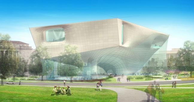
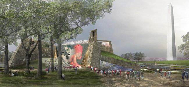
Submissions have just been unveiled this afternoon for six innovative entries in a competition to design the planned Smithsonian Museum of African American History and Culture, a $500 million project scheduled to open in 2015. The six competing teams are: Devrouax & Purnell with Pei Cobb Freed & Partners; Foster and Partners with URS; Diller Scofidio + Renfro with KlingStubbins; the Freelon Group, Adjaye Associates and David Brody Bond with SmithGroup; Moshe Safie and Associates with Sultan Campbell Britt & Associates, and Moody Nolan with Antoine Predock Architect.

Above is a rendering of Diller Scofidio + Renfro and KlingStubbins's avant garde submission; a rendering of Moody Nolan and Antoine Predock's proposal is below. Looks like the Smithsonian -- a fairly traditional institution, when it comes to architecture -- is planning to give the National Mall a bit of archi-juice. And we thought the National Museum of the American Indian's building was a departure!

It's always refreshing when, once in a blue moon, all of the entries in a competition are genuinely interesting, no?

(Photos from the Washington Post.)

Friday, March 6, 2009

The Living...The Built...The McDonald's Parking Lot


You may not agree with TS Eliot’s statement that every age gets the art it deserves, but it’s hard to argue that we don’t—to some extent—get the cities we deserve. In fact, a city may be human culture’s most perfect expression of collective will, a direct and tangible product of millions of individual decisions multiplied by thousands of days. Certain forces, people and institutions tend to exert disproportionate influence on the way cities evolve, but by and large the masses make the cities, and without all those people cities would not even be cities.

Human culture produces cities, and cities in turn influence those cultures. Eliot thought the same about art, and art’s cultural role is more limited than that of cities. Does this mean that subpar cities are created by subpar cultures, and can one expect crappy cities to foster even crappier human relations in their streets and buildings? Are planners, architects and other creators of the built environment to blame for the desolation of downtown Detroit or for me not knowing my neighbors?

Probably not. Architectural historian Spiro Kostof made this unexpected yet intuitive point in his 1987 commencement address to UC Berkeley’s College of Environmental Design:

“Cities are amalgams of the living and the built, always tidying up, never finished. Their agenda is colossally overburdened, its charge near impossible to rein in. There is no way in which design alone will breathe life into a dying enterprise, any more than a vibrant sense of community can be attributed in earnest to the act of design.”

Kostof’s speech—at least that part of it—amounts to a call for more piazzas. That is, more free spaces where human activity can run its course, whatever that turns out to be. The life and energy teeming within cities is bound to find its own way, perhaps guided and elevated by the Burnhams, the Olmsteds and the Koolhaases but never steered by them.

The most vibrant public space near where I live happens to be the neighborhood McDonald’s. Although there’s a beautiful, expansive park only two blocks away, a large group of elderly gentlemen are congregating in that McDonald’s from morning until evening on any given day of the week, usually having nothing more than a coffee. During the summer, they bring their own chairs and hang out in the parking lot. The place is full of people every time I pass by. I opt for the big park when I want to get out of the house, but for some variety of reasons many others find the Golden Arches to be a suitable piazza of sorts. I can tell you this much: They aren't there for the food.

Many view McDonald’s (and parking lots) as the worst American culture has to offer, and more than a few planners would raze every McDonald’s in sight given the opportunity. Builders and planners can only build and plan, though. They can’t actually add the people or dictate the uses of their creations. Ultimately, I think, we do get the cities we deserve because, to a great extent, we are those cities.


(Photo from Flickr user brtsergio.)

Tuesday, November 18, 2008

O'Reilly Talks San Francisco Values


I haven't been to San Francisco yet myself, and I have heard tell of their massive homeless population, but this all seems a bit...skewed. Especially considering the source. It's an interesting piece of propaganda, though, and it speaks volumes about the far right's conception of cities. What I find most interesting is the attempt to paint New York as tame and orderly in opposition to San Fran's off-the-wall liberal madness. Seems to say more about New York than it actually does about San Francisco.

Thoughts?

Thursday, July 10, 2008

Digital Density

CHICAGO, 2008


Dense concentrations of people = dense concentrations of information. Will the NIMBYs of the digital city complain about websites that ruin the character of neighborhood infoclouds? Or perhaps block new sites from launching because they displace smaller, scrappier sites with more interesting content? Will the artistic streetpunks and art insurgents of tomorrow be carefully and sneakily grafting their tag onto Flickr images?

Is the future of urban activism electronic?

Tuesday, March 18, 2008

It Takes a Video Game to Save a Village

Most cities have a love-hate relationship with tourists -- civic officials love them, and residents hate them. Tourism generates billions of dollars in revenue for cities across the globe each year. The number of traffic accidents caused by tourists not watching where they're walking? So far, no reliable estimates have been made.

Still, tourism is a vital part of any urban economy. Even moreso, it can be a powerful factor for a neighborhood that is trying to lift itself up. Tourism As Economic Strategy is a well-worn path. But with all of the emerging technologies related to the web and wireless communication, it seems like the old urban tourism formula (cleaned up historic buildings + quirky neighborhood attraction + Starbucks and/or Cold Stone Creamery and corresponding independent cafe/gelato bar = success!) is due for an overhaul.

Let's start by thinking small, with the traditional Japanese village. Japan's demographic woes have been well-reported over the past few years; indeed, as young residents of this highly urbanized island nation put off having families and move to the cities in droves to pursue fast-paced careers, the raw population number isn't the only thing being affected. Culturally, Japan is seeing the evaporation of its small villages, and the slow death of ancient rural and cultural traditions.

Enter: mixed-reality gaming. An explanation, c/o Very Spatial: "One of the areas of convergence for location-based applications and gaming is the idea of mixed reality, where places in the game correspond to real-world locations, and actions in one lead to events or consequences in the other." A recent Nintendo DS game, Treasure Quest: Enoshima, follows this very blueprint, using a small island north of -- surprise! -- Tokyo as the setting for a handheld video game. Players have to visit and explore the actual island to play the game. The DS unit acts as the mixer, blending the fictional and real worlds, literally with the push of a button.

The problem with Treasure Quest, though, is that it's over. The software could be downloaded off of the internet, and the game only ran until February 19th. Makes sense, considering that Nintendo doesn't own the island, and thus can't stake any real claim to it. But what if they could? What if, as a way to draw in tourists, a rural village somewhere in Japan agreed to sell off a large number of its abandoned buildings to Nintendo in an agreement to become the permanent setting for a mixed-reality video game?

It sounds crass at first, but with the right amount of finesse, it just might be a win-win economic development strategy. For instance, to prepare the town for guests (players), Nintendo would agree to upgrade local utilities. It would also take on the responsibility for upkeep of public areas. Streetscaping, garbage collection, and parks maintenance would be taken care of by the entertainment giant. Villagers would enjoy a higher quality of life at a lower rate of taxation (though I'm assuming the American system there since I know very little about the governance of rural Japanese villages). In return, residents would agree to coexist peacefully with players. A particularly savvy game designer would craft the game as a cultural experience, creating some sort of mystery or adventure plot that made use of the area's native traditions.

The argument could be made that Nintendo (or whatever company helmed the project) was being given too much power over a municipal entity; it could also be said that cultural traditions were being bastardized and pillaged in the name of commerce and fleeting entertainment. But when the options for the village are Sink or Swim, the picture becomes less black and white. After all, don't most -- if not all -- preservation efforts (architectural or cultural), on some level, tokenize the very things that they aim to preserve?

So assume that Nintendo creates a mixed-reality game around a rural Japanese town, and it becomes a wild success. Players start booking rooms at a nearby hotel months in advance for their chance to play. The villagers find new opportunities to pass along their cultural history and traditions. Nintendo makes a buttload of cash. Everyone's happy. A small town in rural Portugal hears of the success and decides to give it a try. Sony's European headquarters gets a call from the mayor...

Ten years later, mixed-reality gaming has become an economic silver bullet. Hundreds of villages in countries around the world have mixed their realities with fantastical virtual counterparts. The trend goes big-time when the city of Detroit sells a square mile of its infamous "urban prairie" to the Walt Disney Co., which painstakingly re-creates the neighborhood circa 1930 to stage a depression-era mob mixed-reality urban epic. The arts & crafts bungalows are the hotel. Visitors live in the game. A month later, Blizzard Entertainment announces a joint deal with CCTV and the city of Shanghai to buy up hundreds of defunct surveillance cameras and create the world's largest multi-player mixed-reality on-and-offline mega-game. The setting? Pudong.

Of course, it must be asked: when is the reality in question no longer considered to be mixed? When does "mixed" become simply "augmented?"

(Photo from Flickr user Mathias M. The original full-color version can be viewed by clicking the photo.)


Links:
Mixed Reality Gaming In Japan (Very Spatial)

Sunday, March 16, 2008

Joie de Vivre Urbaine

"...And joie de vivre [joy of living] may be seen as a joy of everything, a comprehensive joy, a philosophy of life..."

Long ago, writers disparaged cities like London, New York, and Paris, labeling them as hives of disease and destitution. But over time, industrialization and economic growth powered by these urban centers lifted hundreds of millions of people out of poverty, creating a prosperous and secure middle class like the world had never seen. Over the past few decades, we have seen this happen again in China and India. With the rise of ideas like common wealth and the urban planet, it seems less naive each day to believe that this trend could continue moving upward, creating a globalized standard of living (not to be confused with a singular global culture, which would be intensely boring).

But the current model of urban living, with its sprawl, auto-dependancy, and tokenization of nature, is unsustainable at best. If economic development in developing world-cities is to diminish poverty at any notable rate, everyone -- in worlds both "first" and "third" -- must work to bring about the evolution of their cities into healthy, green, globally-minded places. The City As Solution to Climate Change and Globalization Pains has been a popular topic of conversation of late. But how can people in developed countries be persuaded to agree?

As we step into this new Urban Age, those of us arguing for the City As Solution must focus on the joie de vivre urbaine. For cities to reach their full potential as engines for change, the urban chorus will need to grow louder and brighter. The masses should be reminded of the joys and conveniences of living in vibrant, eqitable urban neighborhoods, not guilt-tripped out of their McMansions and driven into gentrifying neighborhoods to exacerbate socioeconomic inequality. Only when a person believes that they will enjoy something -- and that they deserve to -- will they make a real effort to change their way of life.

This week, as Where wraps up its first year in the urblogosphere, each day will feature a post that celebrates the excitement, promise, and possibility of the urban environment. It's Urbanism For Fun (but no profit). A preview:

Monday: EXPLORE
We'll start off by looking at how Google Earth and online mapping sites are making urban places more exciting by helping urbanites develop a better understanding of their cities, and how this type of technology could affect urban culture and society in the future.

Tuesday: PLAY
Taking another look at mixed-reality gaming, Where will consider this emerging form of entertainment as a possible catalyst for economic development in the near future.

Wednesday: IMAGINE
If you could rethink how cities are built, how would you do it? It's a question many of history's most famous architects have taken on with relish. In a guest post by SOM design associate Ella Peinovich, who participated in an architecture studio that took on this very daunting challenge, we'll learn more about what it's like to go through the process of radically reimagining the urban form.
(This has been edited to reflect a change in content).

Thursday: LEARN
Thursday will feature Where's full review of the buzz-heavy book The Endless City, compliments of Phaidon.

Friday: CREATE
March 21st marks the 365th day since Where's first post. To celebrate this blog's "birthday," a special edition of Weekend Reading will look back on the top ten posts of the past year.

--

DON'T FORGET
The Blogedanken game will be open to entries through 11:59pm CST, this Saturday, March 22nd. Go play and submit your favorite results for your chance to win a copy of PA Press' Hyperborder.

(Photo from Flickr user Shimrit&Yaar. The original full-color version can be viewed by clicking the photo.)


Links:
Joie de vivre (Wikipedia)

Hyperborder (Princeton Architectural Press)

Friday, February 22, 2008

WEEKEND READING: February 16-22, 2008

You know how once a month or so Weekend Reading starts off with me getting all excited and writing something along the lines of "OMG you guys this week is SO GR8!! Read all of these they are AMAZIN! FURRILZ!"? Well, this is one of those weeks.

Read all of these. They are amazing. For reals.

ITEM ONE: Tijuana's enterprising spirit influences the design of a new affordable housing project in Hudson, NY.

ITEM TWO: Airoots features another great post about resistance to the Dharavi Redevelopmet Project in Mumbai, this time focusing on the efforts of the fiercely independent neighborhood of Koliwada.

ITEM THREE: Hayley Richardson on the obnoxious futility of twenty- and thirtysomethings bemoaning the loss of "authentic New York," a place that most of them never really knew in the first place.

ITEM FOUR: All About Cities pulls some great Lewis Mumford quotes, including the following gem: "The chief function of the city is to convert power into form, energy into culture, dead matter into the living symbols of art, biological reproduction into social creativity."

ITEM FIVE: A spectacular and almost disturbingly detailed map of London, reimagined as an island. (Photo credit)

ITEM SIX: Part IV highlights some recent articles about the Untergunther, a subgroup within les UX, which is itself a group of people "who are on a mission to uncover and exploit the city’s neglected cultural underworld."

ITEM SEVEN: AdaptiveReuse.net is a blog about creative adaptive reuse projects around the world (natch).

See, what did I tell you? That's some good stuff right there. See you next week!

Friday, December 21, 2007

WEEKEND READING: December 15-21, 2007


Welcome back to another Weekend Reading session, everybody! We have another good batch this week, but if you've only got a little time, make sure to check out Items One and Two.

ITEM ONE: A spectacular piece in The Walrus' Cities Special Issue on suburbia, commute times, and the economics of happiness. Don't miss this one!

ITEM TWO: Simmons Buntin, founder of Terrain, blogs at TNAC on the role of beer in creating the urban-rural society.

ITEM THREE: Some interesting musings on gentrification from a recent transplant to Brooklyn.

ITEM FOUR: Airoots on high-rise squatting in Mumbai.

ITEM FIVE: Megacities all over the world are starting their own climate change initiatives, including one Cuban city that's using horse-drawn carriages for mass transit!

ITEM SIX: The Economist on the Bali climate talks.

ITEM SEVEN: Planning a trip to Rotterdam this February? Make sure to check out The Mobile City conferrence on the 27-28th.

While I have your attention, I want to mention that I've just started blogging over at The Next American City's blog, The Street. I'll be covering all things related to leisure and public life in American cities. If you're interested, you can check out my first post here.

(Photo from Flickr user sarako. The original full-color version can be viewed by clicking the photo.)

Friday, December 7, 2007

WEEKEND READING: December 1-7, 2007

Back to business as usual this week for Weekend Reading. Thanks again to Colin for taking over during November, and thanks once more to all of the guest bloggers who helped to keep Where chugging along during NaNoWriMo!

ITEM ONE: It's BLYGAD 2.0! Tumble Like You Give a Damn, folks.

ITEM TWO: The Architectural League of New York has put out a call for entries to its Young Architects Forum competition for 2008.

ITEM THREE: In the past, little attention was paid to South America and its blossoming cultural scene. Not much has changed, there, but Line of Sight dug up a great article from a 1916 New York Times on the subject.

ITEM FOUR: Subtopia has a post called "Squatter Imaginaries" that contains some of the coolest images you'll ever see. (photo credit)

ITEM FIVE: Giant scale model of a partially destroyed downtown = kickass display for your living room.

ITEM SIX: The Future of Cities on what Jane Jacobs might have thought of Facebook.

ITEM SEVEN: Things Mag starts a recent post off with some interesting ruminations on destruction and redevelopment in the UK. Much link love follows.


'Till next week, happy surfing.

(Photo from Flickr user shadeofmelon. The original full-color version can be viewed by clicking the photo.)

Wednesday, December 5, 2007

The Craig Hartman Interview - Part II

This is the second part of Where's interview with Craig W. Hartman of SOM San Francisco about the firm's Treasure Island redevelopment plan. You can find the first part HERE.

----------------------------------


Where: Thanks for bringing up the neighborhood context, because that's exactly what I wanted to talk about next; you've provided my segue for me. The SOM San Francisco site has a description of the Treasure Island (TI) project and it goes into some of the details [of this plan], and one of the terms that keeps popping up in that is "island life." I got a kick out of that, because there's this idea of island life and, traditionally, I think you kind of think of the Caribbean -- you've got the drink in one hand and you're laid out on the beach and there are palm trees. There is a very relaxed and social connotation to "island life"...I'm interested in how you're creating community on this little island, because it is separate from the main city. As much as it has been integrated through transit, it's going to be sort of off on its own in some ways. So how is community built, and how is that urban lifestyle cultivated through the way that the site is designed?

Craig Hartman: That is really the crux of the issue here, and an interesting question, because I don't think anyone can really know what the nature of social and cultural life will eventually be on the island. The idea is to understand the unique culture of San Francisco and to try to find a way to transplant that to this island. And yet the island is a place apart and it’s culture is obviously going to morph into something that has its own character. I think most people would agree that one of the qualities of San Francisco culture is a very strong spirit of inclusiveness. I think there is an ethos held by the majority of the people who live here that accepts different lifestyles, and that an ethos that really honors the public realm; maybe even to give preference to the public realm over private interests. And there is certainly an ethos here that values environmental stewardship.

The social and cultural life of the island will evolve in a way that reflects the values of those who live there. What we are trying to do is to make the place one that provides a very rich set of public spaces that are consciously designed to encourage this idea of social connection and, hopefully, social inclusiveness. There are some very basic, pragmatic things being done about diversity of housing types that will cater toward a wide variety of demographics: of young single people, of families, wealthy people and people who have low and middle incomes. The idea is to make this a mix of the sort one would find in a real city, not an artificial, gated community with a single monoculture.

So we're trying to find ways in the planning of this island and the design of its architecture to enhance those qualities. That's what we mean when we talk about an urban ecology. We need to consider how we [can be] good stewards of the natural environment, but at the same time, we also want to think about the anthropological quality of this place, and that has to do with the culture. So on Treasure Island we are trying to weave the two together into a holistic ecology that brings together the natural environment and human culture.

And yes, "island life" as you suggest, brings Margaritaville to mind, but the intent is to make an authentic place that recognizes its unique place at the beginning of the 21st Century and in the middle of San Francisco Bay.


W: One of the big principles behind public space right now that's really getting a lot of attention is the idea of deliberately designing for a mix of different uses, too. In addition to designing for a large variety of people, you want it to be spaces that are used at all times of the day and night. Are these pocket parks a way of trying to make this -- I don't want to say a 24-hour neighborhood, because that has it's own cheesy connotations -- but was there an attempt to create social spaces that kept this neighborhood going at all times of the day and night, essentially?

CH: Yes and a lot of this is going to be evolving over the long gestation period of the island’s development period. Right now we are marking the basic intentions. As for the design, some of these parcels of land will be developed by various different developers. There will be many different architects involved over time. So all of these ideas will be evolving. Right now, we're trying to set in place a very strong framework that encourages certain things to happen. In terms of the smaller neighborhoods, the idea is that there will be a provision for flexible community space that provides a place for people to come together for various informal activities. These could range from someone setting up a fruit stand on a Saturday morning to providing a place for community gatherings or a barbeque or smaller retail-oriented spaces. Basics like dry cleaners or a shoe shop or coffee shops will be provided within smaller spaces spread throughout the neighborhood parks. This is an experiment that will be tested over time, to see how much and what kind of life these parks should have.

The development will also incorporate retail and entertainment -- restaurants, cafes, boutiques along grocery and produce and other neighborhood serving retail – in concert with the historic buildings along the Marina side, which faces Yerba Buena Island. The intention is to allow the neighborhoods to be fairly quiet places in the evenings with just the right balance of life, while having the high activity entry zone on the southeast corner of the island where everyone, residents and visitors alike, arrive. One of the challenges of broad mixed use is that the developer’s analysis has shown that this island cannot support a significant amount of office space. Therefore, [the plan] is heavily weighted toward residential. There will be some professional office space, but not a lot. I am sure that as excitement builds when the project starts there will be more interest by cultural institutions as well.


W: Let's step in a slightly different direction and talk about the architecture of the buildings on the site. You said that this is going to be developed over a long period of time, probably by different developers with many different architects, so...are there architectural guidelines for what's going to be built, or is it kind of a "design as you will" attitude, or how is that being approached? Because there's definitely a pretty solid aesthetic to the renderings that have been produced so far. It's very modern, with the crystalline towers...

CH: I worked on a series of ideas which we translated into a drawing for an exhibition that Darrin Alfred of SFMOMA and Julie Kim curated for the AIA in September called Street Cred. It was a speculative rendering of one of the streets on TI that does convey ideas I hope will be carried through in the island’s architecture. The drawings illustrate buildings that have a very strong orientation to the street. I worked with Tom Leader on the environmental ideas and you'll notice that the landscape favors a kind of riparian aesthetic that's much wilder, or natural, than what you might think of as usual in more formal urban landscape architecture. It is my personal belief that the defining architectural aesthetics must have an authenticity which includes the issues we have been discussing regarding setting and place and especially recognizes its temporal setting – that is, the beginning of the 21st century and contemporaneous aesthetics. How specific the base developers and the master plan architect can be in terms of the aesthetics of the island is going to be something that will be evolving. From a personal point of view, I am not a great believer in rigid architectural guidelines. As an architect, I've often found them unnecessarily constraining. Often they rigidly define a singular set of ideas frozen at a point in time and don't allow for the kind of contemporary spontaneity that happens when things are built over years or decades.

The architecture of great cities has an organic quality that incrementally develops. So the goal here will be to find a way to encourage a kind of familial overlay but with it variety. The important thing is that all the work be ambitious architecture. To achieve that requires recruiting the best and most talented design architects to work on the various components over time. It should be a rigorous process. I hope I qualify for a piece of it….


W: So the renderings that exist now, where there are generic buildings for the low-rises for the most part, there are the high-rises as well, which certainly have a more distinct look to them -- the main tower is what I'm thinking of, really -- so are those designed to be built as they look here or are those just massing studies or examples of what could be.

CH: Well they are massing studies, but they are inspired by a set of ideas that are consistent with the overall island design. These renderings represent a very clear attitude about the relationship between architecture and the natural environment. The low-rise buildings are designed to shelter public space from the wind. The height and scale are related to the scale of the spaces they define. We are working on making very narrow streets to create a sense of intimate public space and maximize the potential for social interaction. Most of the people on the island, approximately 75%, will be housed in these lowrise homes.

The mid-rise buildings are the ones that are typically positioned at each of the neighborhood parks we discussed earlier. These small towers mark each neighborhood cluster on the skyline, providing an overall sense of identity and place. These towers are intentionally placed on the north and west sides of these parks to allow the maximum amount of sunlight in the public spaces while providing a wind buffer. And the shape of the towers themselves, if you look at the plan, is a lozenge shape or kind of a rounded trapezoidal footprint. It's like a sailboat, with the bow pointed into the wind. We are presenting the smallest face to the west to let the wind slip by the building with minimum disturbance. Tall buildings can create what we call a "sail effect," where the face of the building that is the leeward side tends to lower wind pressure and bring wind down into public spaces. We have positioned these buildings on the island to minimize any negative effects of wind at the pedestrian scale.

Finally, the tall buildings as shown in the drawing are shaped in a way that is meant to convey a very organic aesthetic. The intent is to create towers that might be more aligned with a cyprus or a redwood than with a machine-made object. We are able to do this because our computers today allow us to analyze structures in ways that are much more supple and nuanced than we ever could have fifteen or twenty years ago. Consequently, we are able to create what was shown on that rendering: the form of an exoskeleton that provides for the seismic bracing of a tall building while allowing for a great deal of glass around the perimeter so we can have as much light as possible inside the building.

The shapes of the buildings will be tested further. The intent is to develop a language that reinforces the basic tenets of the island plan. The aspiration should be for a level of authenticity that can serve as an example to inspire those architects who come after us rather than writing down a set of rules that they have to follow. The most critical issue is to achieve a uniformly high level of architectural excellence, not architectural uniformity. This comes back to the need to consistently select the best design architects – and the need for a mechanism or process to make sure that happens over the course of the island’s development. It should be a highly sought-after honor in the 21st century, as it was for example during the last half of the 20th in Columbus, Indiana, to be selected to design a building at Treasure Island.

W: So it's more of a general aesthetic design than the hard and fast architectural code that, actually, the suburbs get a lot of flak for.

CH: Exactly.


W: The one question I wanted to ask to wrap up would be that I read something about this having some level of approval from the city...is it the plan that was approved?

CH: The basic land concept was approved by the TI Development Authority and has been very well received by virtually all stake holders and the public. But the process continues….

W: Alright. So what is the general status of the project right now?

CH: The general status is that is the negotiation process with the Navy regarding the transfer of the land is continuing. But I understand it is coming to a final resolution, so we are now re-starting again our detailed planning studies to take it to the next stage.

----------------------------------


Thanks again to Craig for doing this interview. Where is looking forward to seeing this project break ground!!


Links:
The Craig Hartman Interview - Part I

Bending the Grid (SOM) (photo credits)

Saturday, December 1, 2007

The Linkdump

NaNoWriMo 2007 is officially over! Congrats to all of the participants around the world who made it past the 50,000 word mark before midnight last night. As for me, I crossed the finish line around 11:30pm. Now I'm trying to catch up on my reading from the past month. Here's a quick jolt of urbanism for all you lazy folks spending Sunday in bed with a laptop and a latte. Happy December, everybody!

Contemporary World Tour goes to Brasilia {} dezeen scopes out the Wind Dam {} The difference between community and "associations, citizen committees and commissions" {} Coney Island wasn't broke, but they fixed it anyway {} A great piece on Jean Nouvel (or: Rupe hasn't killed the WSJ yet) {} The Antisuburbanites {} Toronto embraces its ugliness {} Invisible Landmarks in LA {} GOOD on Homeboy Industries {} Age-old rule #834: Don't understand it? Call it a gimmick! {} Check out the clusters on this map {} Belfast murals at WebUrbanist {} Sarcasm, light rail, and overbearing parents {} Digital Urban calls for a Second Earth {} Who's squatting the squatters? {} The corporatization of Universities {} Bad planning Mixtape {} The World Edition on architecture in Bucharest {} The Urban Planning Generation {} Commercial Revitalization Conundrums {} 26 Different Endings {} Incredible Nonphotography (photo credit) {} Guerilla culture in Paris via Spacing Wire {} Bannerman: The Willy Wonka of Weaponry {} Getting serious about agriculture {} Obama's urban agenda {} Cheering congestion in Sydney {} Gentrification: flood or forest fire? {} Mobile Metrix {} Report from Pakistan {} Downtown revitalization goes Hollywood {} Brazil halves extreme poverty {} Neighbors Project's 7 Rules for talking about gentrification {} The Happiness Project on the benefits of wandering {} Jane Jacobs podcast! {} The best sites for urban photography {} Milwaukee's industrial legacy is fading {} Wikiurbanism {} Miss Representation strikes again {} The City Fix (great transportation blog, added to sidebar) {} Cool Town on Trendwatching's 8 trends for '08 {} Integrating transit and land use

Tuesday, November 20, 2007

National Geographic's Maps: Tools for Adventure @ the Museum of Science and Industry

If you typed the word "maps" into Google and then visited the first ten sites on the results page, you might get a good idea of what it feels like to walk through the Museum of Science and Industry's exhibit National Geographic's Maps: Tools for Adventure, which is part of the citywide Festival of Maps. That is to say: a nuanced overview of mapping technology, this is not. While the exhibit is kid-friendly, it tries a bit too hard to go after the attention deficit demographic. Thematically, the "tools for adventure" theme is the loose string that sort of ties things somewhat together, almost. In fact, between this, the City of the Future exhibit earlier this year, and the Christmas Around the World disaster that we'll discuss in a minute, I'm beginning to wonder if, perhaps, this legendary museum is just coasting on its historical reputation these days.

But, before a tangent begins, let's get back to NGM. The exhibit is, in plain terms, an awkward hybrid of a video arcade, a preschool classroom, and a museum installation. There are kiosks set up throughout several rooms, as well as a block table (a kid-friendly trick MS&I tried with City of the Future that still feels misplaced) and a large foam-block pyramid puzzle. Add to that a moon rover used for mapping Mars, a fake stargazing setup, and an airplane cockpit with plenty of buttons and levers, and you have an intellectual seizure that can even make the grown-ups a bit dizzy.

If the organization of the content is less than stellar, it should be noted that there are some interesting items on display. A portion of an old scroll map of the Mississippi River makes an early appearance, as does an early map of Disneyland (which is cooler than it sounds). But the overall effect of the topical schizophrenia is that, unfortunately, individual pieces get lost in the muddle. Even for someone used to clicking through a few hundred articles and websites a day, the wide variety of topics covered here was so overwhelming that it got downright boring halfway through. When the brain is presented with too much information, it shuts down. I shudder to think that this is the way the curators at one of the nation's most prestigious museums think that children should be taught (to be fair, the exhibit was organized by the Children's Museum of Indianapolis and the National Geographic Society, but MS&I agreed to host it).

But the real jaw-dropper of the day was not the FoM exhibit, but something tangentially related. Apparently, it is customary for the MS&I to put together a Christmas Around the World exhibit. I haven't been to the museum to see past iterations, but this year the exhibit involves Christmas trees decorated to represent "customs" from countries around the world. This provides the museum with a fabulous opportunity to combat Americans' infamously low geographic knowledge, which it squanders on an embarrassingly simplified version of global cultures.

To wit: Mexico's tree is decorated with dozens of felt-cutout Mexicans complete with sombreros and ponchos, Ireland's is dripping with kitschy shamrocks and jigging leprechauns, and there is a very purple Native American Christmas tree that's decked out in a gazillion of those hexagonal things you make out of yarn in kindergarten. Japan's and China's trees, meanwhile, are both covered in oragami (but the China tree uses fluorescent paper, so it's totally different), and (tellingly) the United States' tree is wrapped in red, white, and blue crepe paper and cardboard cutouts of the 50 states and the US outlying territories. It's as strange as it sounds. In fact, it's worse in person. The entire exhibit has the icky, sticky feeling that comes from seeing or hearing something that you don't quite want to call racist, but can't help admitting is kind of leaning in a generally gross direction. The museum's website claims that the trees are decorated by Chicago's ethnic groups to represent their cultures. And to that I say: whaaaa? If that's the case with most of these, it makes me kind of sad.

So if you are looking to learn about the world and how it was and is shaped and explored, skip the MS&I and check out the Field Museum instead. Or the Newberry Library. Or, you know...Google Maps.

But, just in case you want to see this stuff for yourself...

IF YOU GO
National Geographic's Maps: Tools for Adventure is on display at the Museum of Science and Industry until January 6, 2008. The museum is open Monday – Saturday from 9:30 a.m. to 4 p.m, and Sunday from 11 a.m. to 4 p.m.; the admission fee is $11 for adults, $9.50 for seniors, and $7 for children under 11. There is no student discount. Christmas Around the World also runs through January 6. While you're in the Hyde Park area, check out The Virtual Tourist in Renaissance Rome: The Speculum Romanae Magnificentiae, the University of Chicago's contribution to the Festival of Maps.


Links:
National Geographic's Maps: Tools for Adventure (MS&I)

Christmas Around the World (MS&I)

The Virtual Tourist in Renaissance Rome: The Speculum Romanae Magnificentiae (U of C)

Festival of Maps

Monday, November 19, 2007

Airoots Gets Lost in Deep Urbanmess (Guest Post by Matias Sendoa Echanove and Rahul Srivastava)

We arrive at a narrow commercial street lost somewhere between Bombay and Tokyo. It is crowded with pedestrians, bicycles, street vendors, food stalls, and wandering cows and dogs that don’t allow cars to pass through. Most of the buildings lining the street are two to three stories high, covered either with faded, dusty shop-signs painted in art-deco fonts, or snazzy neon lights. Billboards with smiling Manga faces and Bollywood movie stars eye each other warily.

An intricate web of wires, pipes, pathways, and cables connect the buildings, huts, cottages and shop-fronts to each other. They hang overhead or lie snugly underground. They are like masses of snakes intertwined into each other – alive and organic. They buzz with whispering voices, crackle with coded e-mails and crisp exchange of smses, gurgle with water or sewage and are swollen with pornographic images looking for immediate release, along with religious icons that appear on screens of high-tech devotees who bow to them in tiny studios.

The air is abuzz with invisible energy fields. Wireless networks that feed on cables and transmit the cyber-world into this dense neighbourhood. They compete for airspace with the smells of food, fish, gutters, and incense and the crowded sounds of the city.


Walking through the gulleys and streets one sees second-hand electronic shops selling tiny bits of chips and wires. We bump into a bull, resting in front of a poster selling Chinese medicine. Withdrawing, we stumble over a robot-dog who yelps angrily, snapping mechanically and uselessly at our ankles.

Going deeper one sees nimble hands stripping off circuit-board wires. They magically transform the pieces into copper jewelry that is marketed as tribal art. On one side otakus and geeks wait to devour cheap electronic left-overs – on the other, hippies and high-fashion lovers wait to decorate themselves with re-designed electronic waste.

An entrance to one street looks particularly crowded. It is lined with Japanese tea-shops, Iranian Samovar-houses and Chai-stalls served by kids. Old men and women sip tea, keeping an eye on children playing dangerously close to railway tracks. The street shudders as two trains zoom pass each other – one a yellow and brown old-fashioned rusty local train with open doors and another a sleek silver, futuristic machine made of steel, its windows covered with dark tinted glass.


The sound of new stalls being put up and old ones being pulled down rent the air. A bearded man with wild eyes sells mangas in a makeshift stall right next to an old sadhu with dirty, matted hair, who tells your fortune. The mangaman reads out stories to a group of teenaged girls who giggle crazily as he shows them explicit pictures. The palmist-cum-astrologer catches a hapless European tourist and predicts that he will hook up with one of the teenaged girls, who is already smiling at him.

The two connect and vanish around the corner hand in hand. To be continued...


(All of the images above are photoshop collages of Bombay and Tokyo.)

------------------


Big thanks to today's guest bloggers! Matias Sendoa Echanove and Rahul Srivastava are the bloggers behind Airoots/Eirut. Check out their blog for more ruminations on "adventitious roots, urban forests & villages, natural cities, lost tribes, new nomads, and everything in between."

Monday, November 12, 2007

Mapping Manifest Destiny @ The Newberry Library

From a curatorial standpoint, Mapping Manifest Destiny at the Newberry Library (which is in a gorgeous building, in case you were wondering) is an excellent exhibit. The gallery space where the maps are displayed is large and quiet, and the information is carefully organized into four color-coded areas that chart the history of the North American West through cartography. The four sections illustrate the progression of the continent from exotic terra nova at the edge of the world to civilized nation linked by a sophisticated network of railroads by defining the primary focus of mapmaking in four different eras of exploration. You can basically watch the centuries-long process of the formation of the United States (and Canada and Mexico, to lesser extents) take place in under an hour. In addition, scale is provided by the inclusion of maps that detail Chicago's own growth from a swampy outpost into a major transportation hub for the rapidly-growing nation. It's downright artful curation.

Oh, and the content is pretty good, too. ;-)

In fact, the collection is a perfect illustration of the fourth use of maps as explained by the Field Museum's Festival of Maps exhibit: these are maps that "bear witness to and shape history." The first two sections, which explore Maps for Empire and Maps to Serve the New Empire show the evolution of the shape of North America as ever more sophisticated cartographical methods and new knowledge about the continent became available over time. Centuries-old European maps are on hand, as are some of the earliest maps of several modern major American cities, such as San Antonio, New Orleans, and Pittsburgh (the last one being drawn and annotated by none other than the young George Washington).

Halfway through you'll find a real treat: William Clark's (of Lewis & Clark fame) original, hand-drawn map of the Corps of Discovery's exploration of the American West in search of an overland river route to the Pacific. The edges are frayed and the ink slightly faded, but this is history, staring you in the face. It almost glows; it gave me goosebumps.

While the first half of Mapping Manifest Destiny shows how the land manipulated the people that explored it, the second half shows how, once the continent had been properly charted, people then manipulated the land. This half is separated into Maps for Enlightenment and Maps for Business, and details the United States' growth into a commercial juggernaut. The gridded system of land surveying that directed property sales and distribution as the US expanded westward, spurred on by the ideology from which this exhibit takes its name, shows up here. Maps for Enlightenment features see nineteenth-century text books opened to maps (my personal favorite was the one that color-coded the world on a scale from Savage to Enlightened). Maps for Business covers Chicago's rise to dominance of the field of commercial cartography. Several maps and books by Rand McNally (the company largely responsible for the Windy City's cartographical supremacy) are on display. The Business section is rounded out by maps of the expansion of the nation's railroad system and the California gold rush.

Mapping Manifest Destiny is short, sweet, and to the point. It's certainly not the kind of thing you'd bring the kids along for (especially if they're the crying type -- the ceilings are high, and everything echoes) as the material is presented in a very mature way. But anyone interested in US history (or the art of exhibit curation) will find the Newberry Library's contribution to the FoM to be a truly enlightening experience.

IF YOU GO
Mapping Manifest Destiny is on display at the Newberry Library on Chicago's Near North Side until February 16th, 2008. The library's exhibit galleries are open Monday, Friday, and Saturday from 8:15 am - 5:30 pm, and Tuesday, Wednesday, and Thursday 8:15 am- 7:30 pm; the galleries are free and open to the public. While you're there, check out Ptolemy's Geography and Renaissance Masters in the gallery across the lobby. A short bus ride down LaSalle Street is Encyclopedia Britannica's US headquarters; the building's lobby is host to a variety of maps from the Britannica collection, marking the company's contribution to the FoM.


Links:
Mapping Manifest Destiny (Newberry Library)

Ptolemy's Geography and Renaissance Masters (Newberry Library)

Encyclopedia Britannica

Festival of Maps

Sunday, November 4, 2007

Maps: Finding Our Place In the World @ The Field Museum

About a fifth of the way through the Field Museum's Maps exhibit, I started to feel a bit giddy. As a long-time lover of maps, I'd been looking forward to this -- the centerpiece of Chicago's Festival of Maps -- for months, and it was clear early in my time at the exhibit that I knew that I would not be disappointed. Now, after having a day to reflect, I can honestly (and emphatically) say that Maps: Finding Our Place in the World is one of the most impressive museum exhibits I have ever attended.

Those are strong words, I know, so let that be my one burst of enthusiasm. Henceforth, I'll try to be as objective as possible...I'd hate to do that thing where I puff something up so much that it can't live up to my description. Not that I think it's possible to overstate -- oops, sorry. Almost gushed again.

Divided into seven sections, Maps begins by addressing what is probably the most common use of its subject matter: wayfinding. The content of this section is subdivided into two groups, the Itinerary (one route depicted) and the Network (many routes depicted together). The maps on display set the tone for the rest of the exhibit; there is a great variety of mediums, styles, and time periods represented. Highlights include a section of an ancient 60-foot Japanese scroll depicting the road from Kyoto to Edo (now Tokyo), a 1940s road map of America with road trip routes taken by an anonymous family highlighted and annotated, and an original print of Harry Beck's revolutionary redesign of the London Tube map.

The second section of the exhibit displays maps that give structure to the world. While many maps may not be used directly for getting from A to B, they help us to develop a concept of the vastness of the world around us. The exhibit charts the evolution of mankind's understanding of the planet through maps, showing how they were used to record progress and redefine the world as our knowledge grew. The undisputed centerpiece of this area is a set of two large (about 4 feet in diameter, but I'm guessing) wooden globes -- one that depicts the earth as it was believed by cartographers to look (curiosities include the island of California off of North America's west coast and the near-absence of Australia and New Zealand, though overall it's surprisingly accurate) and the other showing the celestial dome above, with full-color representations (i.e. a scorpion for Scorpio) of the constellations.

Maps are also used, as shown in the third and fourth sections of the exhibit, to show important places and "bear witness to and shape history," in the curators' words. These two collections expand quite nicely upon the logic of the first two; the most obvious uses of maps are to chart the world and the routes that people use to move around it, but with a heightened understanding of the larger world, it makes sense that people started using maps to break the larger world down into smaller parts. Privatization and land division become central foci here. Several important names pop up up in a subset of the fourth section focusing on historical maps of the US: Lewis and Clark's map of their route is here, as are land surveys by George Washington, Thomas Jefferson, Abraham Lincoln, and Benjamin Franklin.

Even more sophisticated maps make up the fifth section, which highlights maps that make the invisible visible. These are highly detailed creations that detail intangible or hidden details about places. One of Jane Adams Hull House's famous maps of Chicago blocks broken down (and color-coded) by ethnicity and income is on display (a print of the same map is included in the Chicago History Museum's Mapping Chicago exhibit). So is a huge, vividly-colored map of the geology of Great Britain, one of the first maps of its kind. Another first here is a small, unassuming map of northern Italy that is believed to be one of the first uses of shading to depict topography, pre-dating its common use in recent times by several centuries. A closer look at the plaque describing this piece reveals that its creator was none other than Leonardo da Vinci. Another of his quiet pieces, a plan to canal-ize the Arno, is nearby.

The sixth area is a showcase of maps that depict imaginary places. L. Frank Baum's map of Oz is here, along with several of J.R.R. Tolkien's hand-drawn maps of Middle Earth. This section contrasts nicely with the seventh, which shows maps in rather mundane use in everyday life. A RISK board, a needlepoint map of Great Britain, a kiosk showing mapping technology on modern cell phones -- these examples point out the many ways in which maps seep into our daily routines. This last section culminates in an interactive wall of video maps where you can touch cursors on large screens and navigate satellite imagery and zoom in on your hometown. (It can be a bit tricky to get these to work -- try holding your fingers a few centimeters away from the screen).

If there is one opportunity that is really missed here, it's that Maps does not spend any time on the way that the internet is currently democratizing the field of cartography. There is no mention of mashups or group maps or even Mapquest, the launch of which really was revolutionary moment for mapping technology (though Mapquest's prominence in online mapping has since been usurped by Google and Microsoft). In fact, I kept expecting to see this theme threaded throughout the other sections of the exhibit, but it never even made an appearance.

Overall, Maps: Finding Our Place in the World is a suitably rich and creamy center to the FoM's gourmet chocolate. It's an exhibit that keeps you moving, looking forward to the next map even before you've finished reading about the last. If you don't live in the area but you've been looking for a reason to visit Chicago, this exhibit would even make a good excuse to come. If you live within driving distance and have even a passing or newfound interest in cartography, you have no excuse not to make the trip.

IF YOU GO
Maps: Finding Our Place in the World is on display at the Field Museum until January 27th, 2008. The museum is open 9:00am-4:30pm, seven days a week; the entry fee for the museum and the special exhibit is $19 for adults, $14 for students and seniors, and $9 for children under 12.


Links:
Maps: Finding Our Place in the World (Field Museum of Natural History)

Monday, October 29, 2007

Mapping Chicago @ the Chicago History Museum

Mapping Chicago, the inaugural exhibit in the Chicago History Museum's new Skyline gallery, is also one of the inaugural exhibits in Chicago's Festival of Maps. The show, which opened near the end of September, divides the spacious new gallery into three distinct areas, each with its own theme, and shows the city of Chicago in various stages of its history, and from a variety of distinct perspectives. Overall it's a bit of a grab-bag, but certainly worth your while.

Cities are places with vast histories comprised of millions upon millions of stories stretched across hundreds (sometimes thousands) of years. As the curators of Mapping Chicago point out several times in this exhibit (most entertainingly, at one point, in the rather incredulous "voice" of the city itself) it is virtually impossible to create a map of a city that really encapsulates what Chicago is about. Buildings go up and are torn down, streets are widened or erased, demographics shift as people come and go, and all of this contributes to the fact that as soon as a map of a place as dynamic as Chicago is made, it is in some way already out of date.

The first area of the exhibit, then, attempts to piece together a historic portrait of the city. From a detailed map of the area destroyed by the Great Fire to a map of the original settlement showing the original Native American trails that crisscrossed the area, this introductory set makes no attempt to show Chicago as it is. The unofficial centerpiece here, a wall-sized full-color birds-eye view map of the Loop from the early 1900s drawn in exquisite detail, subtly underlines the show's message; of the many large and grand structures that surely seemed as permanent as time itself when this map was completed, only a few are still around today. Even monumental constructions like the old Federal Building or the Masonic Temple (then the city's tallest building) are long gone.

It's in the second area that the exhibit sags a bit as it veers rather noticeably off course to demonstrate by video and through several kid-friendly kiosks how two-dimensional maps are formed into globes. Replogle Globes, a major manufacturer of the objects, is a sponsor of the installation. This middle section is interesting in and of itself, as it answers in careful detail one of those questions that you'd never thought to ask but find yourself very curious about once it's been asked for you. Still, the section can't help feeling like a commercial in the middle of a good show since the subject matter is only tangentially (at best) connected to that of the overall exhibit. At any rate, it's fun for kids, and certainly no reason to skip Mapping Chicago altogether.

The third and final area is separated from the other two by a very unconventional map made up of a cluster of very large, very colorful representations of Chicago landmarks. It is a sculptural creation made of oversized drawings by children from around the city that sets the tone for the area of the exhibit that shows how the diverse and divergent perceptions of the city by its many inhabitants over the years has created some very interesting and unconventional maps of the city. A pinball machine printed with a map of the 1933 World's Fair, a color-coded map of building heights in the Loop in the early 20th Century, large digitally-produced maps of SOM's plan for the city's 2016 Olympic bid -- all of these and more are on display in this part of the exhibit. Together, they bring home the message that a city like Chicago is a constantly-changing thing, exciting and mysterious in the way that it constantly eludes the cartographer. The city is the subject in all of these maps, but ironically this collection, brought together, puts the focus on the map-makers. After all, in the end it is the people -- not the physical environment -- that make the city what it is at any given moment.

IF YOU GO
Mapping Chicago is on display at the Chicago History Museum until January 6th, 2008. The museum is open seven days a week; the entry fee is $14 for adults, $12 for students and seniors, and free for children under 12. Hours vary, so check the website for more details. While you're there, if you are in need of some more map action, don't miss the permanent exhibit Chicago: Crossroads of America, which features a number of detailed maps from the city's two world's fairs. Also on display: gorgeous architectural models of the Chrysler Motors and Transportation Buildings from the '33 Fair.

Links:
Mapping Chicago (Chicago History Museum)

(PS -- Where is back in business! Thanks to all of the fine people at the North Michigan Avenue Apple Store who saved my hard drive and, by extension, my sanity. They are awesome.)

Wednesday, October 3, 2007

(Re)Building Intellectual Infrastructure

Richard Florida, Dr. Creative Class himself, spent a good deal of time in a post today on his blog responding to some of the concerns raised in yesterday's Where post on questioning the logic of the CC. I'll admit that I haven't yet read Rise of the Creative Class (yesterday's post was about the phenomenon, not specificlly the book that started it), so reading his thoughts taught me a lot that I didn't know about his argument. As it turns out, I agree with him on more than I had originally thought. From Dr. Florida's post:

"My bottom line is that every human being is creative. And the creativity cannot be forced into the social categories we have imposed on ourselves...The real task is to build pathways to a creative society in which all can contribute and be rewarded [and] in which all engage their creativity at a much fuller level, thereby contributing to economic growth...The key to the future will be to extend the creative force into the service and manufacturing economies - across all segments of the population. The logic of the creative economy is such that the further development of the economy requires the further development of human creative capabilities. We need to shift from a creative economy and a creative class to much fuller and broader creative communities and a creative society."

This plays directly into the follow-up I had planned to last night's post. If cities hope to strengthen the creativity of their citizens in order to secure their economic futures, the officials holding the purse strings need to realize that coffee shops and bike paths aren't going to cut it -- they're the icing, not the cake. As illustrated in the Slate article referrenced yesterday, the creative class will seek out existing creative societies. Cities looking to invest in their creative infrastructure, then, should focus on building up the skills of those who already live there instead of looking to bring new folks in. To paraphrase City Comforts, brilliance innovates, genius follows.

Cities looking to build a creative populace can do so if they are willing to invest in what we'll call their intellectual infrastructure. Civic leaders' first step here would be to create the strongest school system possible -- a major responsibility that many cities illogically refuse to take seriously. That sadly overpoliticized issue aside, cities must find innovative ways to encourage their citizens to develop their own creative skills. It's time that politicians stop looking at citizens as "constituents" (read: votes) and start seeing them as what they are: the city's greatest assets.

In a recent post at atlas(t)'s Galleon Trade Edition, blogger Claire Light waxed nostalgic about the proverbial days of yore: "Once upon a time, before art was professionalized (insofar as people are willing to pay artists, that is to say) folks stayed at home a lot and made art themselves. Every middle class home had a piano, every working class one a fiddle, or a jew's harp. Young ladies drew each other for sport. Young men drooped from the forks of tree branches shouting, 'Beauty!' Jigs were danced, and danced well, on homemade wooden heels, family theatricals taught children the fine art of crying at will, [and] a blank wall was excuse enough for interpretive dance..."

As Dr. Florida (and several readers who commented on yesterday's post) pointed out, creativity is about a lot more than what we traditionally think of as the arts. Creativity and innovation, especially in terms of economics, must be valued in all fields and industries. What the atlas(t) post illustrates particularly well is the way that art used to be intregrated into society; these kinds of activities were much more accessible to the general public. Art-for-fun had no social stigma; it was just something that everyone did. In this way, artistic endeavors served as both social activities and intellectual stimulation. When you gathered around a piano and sang songs with your friends, you got some beneficial social juju and you gave your brain a workout. While you may not have been able to use your piano-playing skills or your ability to sing a high G at work the next day, your musical exploits sent you to the office or the factory with a fresh and slightly-stretched mind.

So what policies or public projects could a city undertake to try to rebuild this kind of intellectual infrastructure that makes creativity a common civic value? One idea comes from a recent airoots post (them again!) about a kind of dwelling in the Dharavi area -- best known as Asia's largest slum -- in Mumbai known as the "tool-house." When is a house a tool-house? "When every wall, nook and corner becomes an extension of the tools of the trade of its inhabitant. When the furnace and the cooking hearth exchange roles and when sleeping competes with warehouse space. A cluster of tool-houses makes for a thriving workshop-neighbourhood and its public spaces emerge as a dynamic by-product of such an auto-organized habitat."

To attempt the transformation of a contemporary Western (or Westernized) city into a tool-house city would be both disingenuous and impossible. What we can learn from these places is a social principle, not a building practice. Tool-house cities are innovative by necessity, but they illustrate "the relationship between production, livelihood and spaces." This relationship is vital to creative cities, where production -- not consumption -- is the primary economic mode of the citizen (think "prosumer").

Cities, then, should invest in projects and policies that reinforce the production-livelihood-space relationship and encourage citizens to apply the skills that they learn on the job to the world around them in new ways. Citizens should also be encouraged by civic leaders to build off-the-job skills as well, as these can also be applied to urban problems and will likely be more potent and flexible when combined with work-related knowledge.

But what, physically, might this kind of thing look like? Perhaps cities could organize and/or facilitate neighborhood skill-shares or tool-sharing programs, sponsor a job-shadow program for adults, or subsidize classes that could teach arts and trade-related job skills (how about a graffiti club that teaches teens masonry skills so that they can learn to build walls to paint on -- and how to clean them off) There are ten times as many solutions as there are problems. Any ideas?

(Photo from Flickr users pbo31 and Soumik.)


Links:
Creative Class Debates (Creative Class Group)

Manalo Juan (atlas(t) Galleon Trade Edition)

Urban Fictions: The Toolhouse (airoots)

Tuesday, October 2, 2007

Questioning the Creative Class Logic

Sometimes I can't help but wonder if maybe the whole Creative Class phenomenon is doing more to harm cities than it does to help them. Not in all cases, of course...certainly many cities are benfitting from the investment in their artistic and recreational infrastructure. But the primary purpose of a city is to provide high-quality services to all of its citizens, and at times it seems like this responsibility falls by the wayside as civic governments try to focus on building Creative Class-friendly amenities.

Gentrification happens because neighborhoods throughout a given city are unequally supported. And while this isn't the fault of the Creative Classmates, they appear to be exacerbating the problem by attracting a disproportionate amount of attention -- and funding -- from mayors who think of their presence as a silver bullet. With rich creative people comes an increased tax base, and with an increased tax base, more problems can be solved in less privileged areas, right?

Portland, Oregon, is seen as one of the capitals of the Creative Class. The city's arts and cultural scenes are thriving, with artists flocking to the once-granola metropolis to be a part of the scene. As a recent article in Slate pointed out, "it's rare to meet a young, creative Portlander who's from Portland." Its success in drawing talent from other cities is, in fact, one of the reasons that Portland is held up as model of the Creative Class metropolis. The CC is all about migration, after all; it could not exist without the internet, which allows for artists to live in cheaper cities while still participating in the larger artistic fields in which they are interested and/or employed.

Jump to the other side of both the country and the spectrum, to New York City. Manhattan and Brooklyn (and, to some extent, Queens) have become inordinately expensive. The city -- or The City, with caps, as it's known Stateside -- has become what airoots recently described as "a networking platform and marketplace for established creative people from all around the world, [but not] much of a place for emerging artistic production within the city." NYC is a popular city with the Creative Class as well; in fact, it is the sun to their universe, around which all things (in some way) orbit. In effect, New York has become the City of Art, while the artists have fled to the hinterland.

But what has made Portland -- or Boston, or Boise for that matter -- a hub of activity for those who have fled New York's rising rents? One of the things that a large chunk of the Creative Class' centers of production share is a strong public services network that pre-dates the city's popularity. They are cities with well-maintained parks, strong transit systems, and clean and affordable utilities (water, electricity, etc.) Cheap space must be available -- again from airoots, the new creative cities "are open and messy enough to provide artists with interstitial spaces they can takeover and make their own."

Walkability, density, urban character -- all of these things are supposedly important to the Creative Class. Yet there are cities much closer to New York (aka the Center) than Portland that offer all of these things in larger helpings yet have failed to tap into the Creative Class boom as effectively as the Rose City. To name a few: Philly (which is starting to benefit from NY's overflow but is still limping considerably), Washington DC, Pittsburgh, Cleveland, Cincinnati, Milwaukee, Richmond. It seems to me that the advantage that Portland had over these places was strong, well-maintained infrastructure. After all, if you don't want to live in New York but you can live pretty much anywhere else, you're going to choose a city that can provide you with the most comfortable life with the lowest amount of stress.

Milwaukee is a perfect illustration of the benefits of maintaining strong basic urban infrastructure -- and what happens when that maintenance falls by the wayside. The city managed, against all odds, to remain in the black into the 1930s while other cities across the US struggled with the Great Depression. This was largely due to the civic integrity of the city government (socialists, for the record) and the fact that they had not been extravagant in their spending during the Roaring Twenties. Milwaukee eventually suffered from the depression like the rest of the country, but anyone who has followed the history of the Midwest can tell you that the Brew City never suffered the kinds of blows sustained (or not) by Saint Louis, Detroit, and Cleveland. After the depression passed, the industrial city roared, and its services remained strong and well-maintained until the 1980s. Slowly over the past twenty-five years, the city and county have been chipping away at Milwaukee's utilities, infrastructure, and once-legendary bus and parks systems. Even with the Creative Class leading a renaissance in parts of the city, crime is at an all-time high and the racial segregation is some of the worst in the nation.

The importance of creativity in the modern economy is nothing to sneeze at. While basic services are something that cities need to focus more heavily on, it is important that they bolster the creativity of their populace. But it seems to me that spending city funds on cultural amenities, building artist housing, and hosting snazzy (and pricey) festivals might not be the best way to go about incubating a culture of innovation and artistic aspiration. If anything, they seem likely to create a dangerous "us and them" tension between the Creative Class and their fellow city-dwellers. In a way, this could even be seen as the institutionalization of the overprofessionalization of art.

So how can cities create a dynamic, creative culture without overreaching? I have some ideas, but this post is starting to get long, so I'll save them for tomorrow.

(Photos from Flickr users gonebiking and Digital Trav.)


Links:
The Indie City (Slate) (via Brand Avenue)

New York Rollercoaster City (airoots)

Urban Fictions: The Toolhouse (airoots)